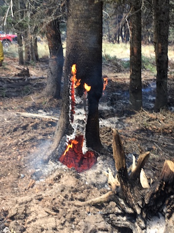
 Fire burning from inside a tree. Photo by Jerry CarrollJune 19, 2018 10:00 AM
San Antonio Fire Statistics
Start Date: June 14, 2018, at 11:30 AM
Size: 495 acres
Location: Northwest area of Valles Caldera National Preserve
Cause: Lightning
Containment: 20%
Rains Not Sufficient to Lift Fire Restrictions and Closures
Fire officials want to stress that the rains received a couple of days ago were not enough to lift the Stage III fire restrictions and closures within the Jemez Mountain area. It typically takes several rain events before the moisture saturates the ground enough to allow the vegetation to restore its dehydrated system. In others words, imagine spending all day outside doing yard work in the sun and heat, but you only get 8 ounces of water to rehydrate yourself, that amount of water just isn’t enough for your body.
Firefighters continue to strengthen hand line on the steep and rocky southwestern perimeter of the San Antonio Fire. Although containment of the fire remains a high priority, the safety of 263 fire personnel is essential. Hazards include snags, fallen trees, steep and rugged terrain, and travel to and from the fire.
Objectives: Firefighter and public safety; containment of the fire while protecting values at risk.
Restrictions: The Valle Grande entrance station and bookstore will remain open to the public, and ranger-led tours and hikes will be offered in the park’s cabin district. All other access and activities have been suspended. NM State Route 4 is open to traffic.
Closures: A temporary flight restriction has been ordered, is in effect over the fire area, and remains in place until further notice. This restriction includes drones or unmanned aerial vehicles. Please remember that “If you fly, we can’t!” The public is reminded that Valles Caldera National Preserve and Santa Fe National Forest is still under Stage 3 Closure due to extreme fire danger, no public access is allowed.
Because of the location and elevation, smoke from the burn may be visible from all directions coming into the Jemez Mountains area. Smoke is expected to linger in neighboring communities including Los Alamos, La Cueva, Sierra Los Pinos, Jemez Springs, Ponderosa, Jemez Pueblo and areas near NM State Route 4. Communities surrounding the Jemez Mountains may also see smoke.
Information on health impacts from smoke can be found by calling the New Mexico Department of Health at 1-888-878-8992 or visiting https://nmtracking.org/fire .
###
San Antonio Fire Information: (575) 737-8147 from 9:00 AM to 8:00 PM NM Fire Info webpage: http://nmfireinfo.com
G-mail: sanantoniofire2018@gmail.com
Inciweb: http://inciweb.nwcg.gov/incident/5845