 NMSU department of geography associate professor Christopher Brown (NMSU photo by Carlos Trujillo).Although New Mexico relies on both groundwater and surface water to supply the needs of the state, about 87 percent of the public water supply comes from groundwater, that is, water held in underground aquifers. But who owns that water?
Under New Mexico water law, all ground and surface waters belong to the public but they are subject to appropriation under the Water Resources Allocation Program. Under this program, the Office of the State Engineer is tasked with keeping track of these water rights. Thanks to a grant from the state engineer, New Mexico State University will be digitizing the state’s water rights database in map form by the new completion date, the end of the year, due to delays with COVID-19.
 Geography graduate alumni Joel Cisneros will work on these maps gaining first-hand experience geo-referencing. (Courtesy Photo)“Proper management of water resources in New Mexico is very important to the State’s economy and the quality of life of the people that live in the State,” said Christopher Brown, associate geography professor in the College of Arts and Sciences and co-director of the Spatial Applications Research Center.
“An important element of sound management is to understand the historical arc of water use, and the project we have been funded to do will allow us to capture in digital form the historic maps of the hydrographic survey of New Mexico.”
The Water Resources Allocation Program at the New Mexico Office of the State Engineer is responsible for processing water rights applications, conducting the scientific research for making those water rights decisions, maintaining water rights records and enforcing any conditions or restrictions on water use.
Daniel Estrada, a geographic information systems analyst at OSE, advocated for NMSU to head the project.
“Having been a student at NMSU in the department of geography, I know firsthand that NMSU has the capability to provide quality GIS products and services,” Estrada said. “NMSU has the Spatial Applications Research Center that has the ability to contribute to our state by providing geospatial services to the state of New Mexico.”
“Tasks involved in the project start with the transfer of digital scans of paper survey maps from the NMOSE to NMSU, this being 888 digital files. Using georeferencing tools in the ESRI geographic information system, Joel Cisneros, the staff person working on the project, then georeferences these images so they are located in correct geographic space,” Brown said. “As we proceed on the project, we are sending batches of maps to Daniel Estrada at the NMOSE for review, and then making any edits required to the maps. As this process moves forward we then mosaic the georeferenced maps sheets into a seamless data layer for the State.
Although he will not actually create the maps, he is helping encode the geographic coordinates of each water rights location, which will be incorporated into the map through the use of black and white aerial photography.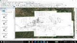 Screenshot of the tools being used to digitize the water rights maps. (Courtesy Photo)“These types of projects provide students an excellent opportunity to deploy skills that they acquire in class to real-world applied geographic riddles and tasks,” said Brown. “This work also provides professional development skills, in that students develop a work flow for the tasks at hand, conduct the specific technical work involved, work with the sponsor to execute quality control/quality assurance, make any needed edits, and track the entire work flow, all skills that the professional workplace requires.”
“This is an applied project that came through the NMSU SpARC Lab, and Joel actually developed the work flow being used in a pilot project. As work progressed on the project, Joel graduated with his master’s in applied geography, and he is continuing this work as a staff person working in the SpARC Lab. We are fortunate to have him on our team.”
Some of the maps currently being used by the Office of the State Engineer are 100 years old and all are in paper format. Creating a geo-referenced and digital library for these maps will help the state better archive and protect the state’s water rights documentation and help in the allocation of water rights in the future.
“Having these maps geo-referenced is going to allow the Water Rights Division the ability to analyze the areas and provide the best information to the people of New Mexico when they need assistance with their water rights,” Estrada said.
Estrada believes the research experience at NMSU is a factor that can make a big difference when graduates like Cisneros are out looking for jobs.
“The New Mexico State University Department of Geography’s undergraduate and graduate applied geography programs have produced some of the best geographers and GIS professionals that are employed in many state agencies,” Estrada said.