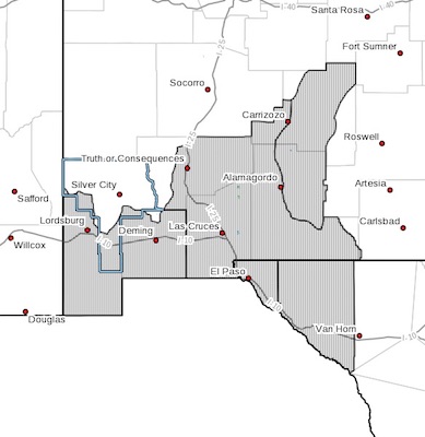
 New Mexico Fire Weather Zone 111
Southwest Deserts And Lowlands/las Cruces Blm/glz-
New Mexico Fire Weather Zone 112
South Central Lowlands And Southern Rio Grande Valley/blm/glz-
Texas Fire Weather Zone 055
El Paso County-texas Fire Weather Zone 056
Hudspeth County-
248 Pm Mdt Fri Apr 6 2018
Red Flag Warning Remains In Effect Until 7 Pm Mdt This Evening For Strong Winds And Low Humidities
For Fire Weather Zones 055, 056, 111, And 112...
Fire Weather Watch In Effect From Sunday Afternoon Through Sunday Evening For High Winds And Very Low Humidities For Fire Weather Zones 055, 056, 111, And 112...
The National Weather Service in El Paso Tx/Santa Teresa has
issued a Fire Weather Watch, which is in effect from Sunday
afternoon through Sunday evening.
A strong fast moving upper level low pressure system will move
into the Central and Southern Rockies Sunday bringing very dry
westerly gusty winds across the region Sunday. Min RH values
should drop below 15% and sustained winds reaching 25 to 35 mph
with gusts to 45 mph. With an abundance of very low fine fuel
moistures in place along with high fire danger, critical fire
weather conditions will develop Sunday afternoon through early
Sunday evening.
* WIND...West Southwest winds of 25 to 35 mph with gusts over 45
mph.
* HUMIDITY...10% to 15%.
* IMPACTS...any fires that develop will likely spread rapidly.
Outdoor burning is not recommended.
* LOCATION...Fire Zones 111,112,55,56.
PRECAUTIONARY/PREPAREDNESS ACTIONS...
A Red Flag Warning means that critical fire weather conditions
are either occurring now, or will shortly. A combination of
strong winds, low relative humidity, and warm temperatures can
contribute to extreme fire behavior.
A Fire Weather Watch means that critical fire weather conditions
are forecast to occur. Listen for later forecasts and possible
Red Flag Warnings.