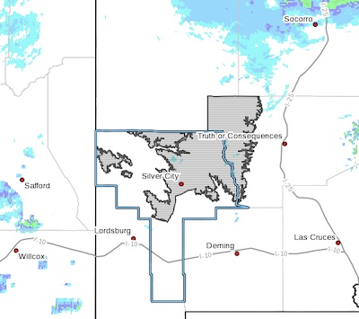
 Southern Gila Highlands/Black Range-
Including the cities of Silver City and Lake Roberts
326 PM MST Thu Dec 27 2018
...WINTER STORM WARNING IN EFFECT UNTIL 5 AM MST SATURDAY...
* WHAT...Heavy snow expected. Plan on difficult travel conditions. Tree branches could fall as well. Total snow accumulations of 3 to 5 inches above 6,000 feet and 5 to 8 inches above 7,500 feet, with localized amounts up to 10 inches, possible.
* WHERE...Southern Gila Highlands and the Black Range.
* WHEN...6 PM to 5 AM Saturday. The heaviest snowfall rates will occur between 11 PM this evening and 5 AM Friday.
* ADDITIONAL DETAILS...Look for significant reductions in
visibility at times. Cold wind chills as low as 0 will cause
frostbite in as little as 30 minutes to exposed skin.
PRECAUTIONARY/PREPAREDNESS ACTIONS...
A Winter Storm Warning for snow means severe winter weather
conditions are expected. If you must travel, keep an extra
flashlight, food and water in your vehicle in case of an
emergency. The latest road conditions for the state you are
calling from can be obtained by calling 5 1 1.
Southern Gila Highlands/Black Range-
Including the cities of Silver City and Lake Roberts
326 PM MST Thu Dec 27 2018
...WINTER STORM WATCH IN EFFECT FROM FRIDAY EVENING THROUGH LATE
SATURDAY NIGHT... for remainder of area of SW NM
Southwest Desert/Lower Gila River Valley-Lowlands of the Bootheel-
Uplands of the Bootheel-Southwest Desert/Mimbres Basin-
Eastern Black Range Foothills-Sierra County Lakes-
Northern Dona Ana County-Southern Dona Ana County/Mesilla Valley-
Central Tularosa Basin-Southern Tularosa Basin-Otero Mesa-
Including the cities of Lordsburg, Antelope Wells, Animas,
Hachita, Cloverdale, Deming, Hillsboro, Garfield, Hatch,
Radium Springs, Las Cruces, Alamogordo, Chaparral, and Crow Flats
326 PM MST Thu Dec 27 2018
* WHAT...Heavy snow possible. Plan on difficult travel
conditions. Total snow accumulations of up to two inches, with
localized amounts up to 5 inches, are expected.
* WHERE...Portions of southwest and south central New Mexico.
* WHEN...From Friday evening through late Saturday night.
* ADDITIONAL DETAILS...Significant reductions in visibility are
possible.
PRECAUTIONARY/PREPAREDNESS ACTIONS...
A Winter Storm Watch means there is potential for significant
snow, sleet or ice accumulations that may impact travel. Continue
to monitor the latest forecasts.