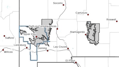
 Southern Gila Highlands/Black Range-
Southern Gila Foothills/Mimbres Valley-
West Slopes Sacramento Mountains Below 7500 Feet-
Sacramento Mountains Above 7500 Feet-
East Slopes Sacramento Mountains Below 7500 Feet-
Including the cities of Silver City, Lake Roberts, Kingston,
Fort Bayard, Mimbres, Hurley, Faywood, Grant County Airport,
Mescalero, Timberon, Mountain Park, Cloudcroft, Sunspot,
Apache Summit, Mayhill, Pinon, and Sacramento
624 AM MST Sun Jan 20 2019
...HIGH WIND ADVISORY IN EFFECT FROM MONDAY MORNING THROUGH MONDAY
EVENING...
The National Weather Service in El Paso Tx/Santa Teresa has
issued a High Wind Watch, which is in effect from Monday morning
through Monday evening.
* TIMING...Southwest to west winds will begin to increase in the
morning hours, before becoming strong by late morning across the
mountains. The strongest winds are expected during the afternoon
and early evening hours. Wind speeds will slowly diminish in the
few hours after sunset.
* WINDS...Breezy southwest to west winds will increase from 15 to
25 mph in the early morning hours, becoming windy to very windy at
35 to 45 mph with gusts over 60 mph in the afternoon hours.
* IMPACTS...Strong winds may bring down trees and interrupt power
service. Strong winds will make driving difficult, especially
for high-profile vehicles. Lofted blowing dust from White Sands
National Monument may reduced visibilities in the Sacramento
mountains.
PRECAUTIONARY/PREPAREDNESS ACTIONS...
A High Wind Watch means there is the potential for a hazardous
high wind event. Sustained winds of at least 40 mph, or gusts of
58 mph or stronger may occur. Continue to monitor the latest
forecasts.