 High Fire Danger Possible on Sunday Afternoon as Breezy Winds Reach Criteria During Warm and Dry Weather... .West flow will increase on Sunday ahead of an approaching upper low from the north. In response, breezy to windy conditions are expected across much of southwest New Mexico during the daytime hours on Sunday, with the strongest winds west of the Rio Grande. Ongoing dry weather will continue through the weekend, resulting in very low relative humidity. These conditions may cause a few hours of Red Flag criteria on Sunday, with the most likely areas being far southwest New Mexico, including the bootheel and I-10 corridor near the Arizona state line. Rapid curing of fine fuels over the past few days will make fire starts dangerous in this location..
222 PM MST Fri Feb 26 2021
...FIRE WEATHER WATCH IN EFFECT FROM SUNDAY AFTERNOON THROUGH SUNDAY EVENING FOR WINDY CONDITIONS AND LOW RELATIVE HUMIDITY FOR
FIRE WEATHER ZONE 111...
The National Weather Service in El Paso Tx/Santa Teresa has
issued a Fire Weather Watch, which is in effect from Sunday
afternoon through Sunday evening.
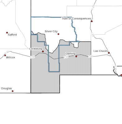
* AFFECTED AREA...Fire weather zone 111 in southwest New Mexico
which includes portions of Hidalgo, Grant, and Luna Counties.
* WIND...Sustained winds from the west-southwest at 18 to 25 mph.
Wind gusts of 30 to 40 mph.
* HUMIDITY...6 to 12 percent
* IMPACTS...any fires that develop will likely spread rapidly.
Outdoor burning is not recommended.
PRECAUTIONARY/PREPAREDNESS ACTIONS...
A Fire Weather Watch means that critical fire weather conditions
are forecast to occur. Listen for later forecasts and possible
Red Flag Warnings.