 [Editor's Note: This has been sent and canceled TWICE today. ???]
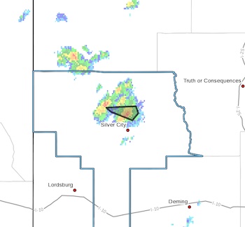
Flash Flood Warning
National Weather Service El Paso Tx/Santa Teresa NM
220 PM MDT Tue Aug 16 2022
The National Weather Service in El Paso Tx/Santa Teresa has issued a
* Flash Flood Warning for...
North Central Grant County in southwestern New Mexico...
* Until 415 PM MDT.
* At 220 PM MDT, Doppler radar indicated thunderstorms producing
heavy rain in McMillan CG and Cherry Creek. Between 1.3 and 2
inches of rain have fallen. Flash flooding is ongoing or expected
to begin shortly.
HAZARD...Flash flooding caused by thunderstorms.
SOURCE...Radar.
IMPACT...Flash flooding of small creeks and streams, urban
areas, highways, streets and underpasses as well as
other poor drainage and low-lying areas.
* Some locations that will experience flash flooding include...
Pinos Altos.
PRECAUTIONARY/PREPAREDNESS ACTIONS...
Turn around, don't drown when encountering flooded roads. Most flood
deaths occur in vehicles.
Be aware of your surroundings and do not drive on flooded roads.
Flooding is occurring or is imminent. It is important to know where
you are relative to streams, rivers, or creeks which can become
killers in heavy rains. Campers and hikers should avoid streams or
creeks.