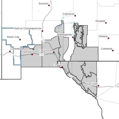
 Southwest Desert/Mimbres Basin-Northern Dona Ana County-
Southern Dona Ana County/Mesilla Valley-
West Slopes Sacramento Mountains Below 7500 Feet-
Sacramento Mountains Above 7500 Feet-
East Slopes Sacramento Mountains Below 7500 Feet-Otero Mesa-
West Central Tularosa Basin/White Sands-
Eastern/Central El Paso County-
Northern Hudspeth Highlands/Hueco Mountains-Salt Basin-
Southern Hudspeth Highlands-
Rio Grande Valley of Eastern El Paso/Western Hudspeth Counties-
Rio Grande Valley of Eastern Hudspeth County-
Including the cities of Deming, Columbus, Garfield, Hatch,
Radium Springs, Las Cruces, Vado, Sunland Park, Mescalero,
Timberon, Mountain Park, Cloudcroft, Sunspot, Apache Summit,
Mayhill, Pinon, Sacramento, Crow Flats,
White Sands National Park, Chaparral,
White Sands Range Headquarters, East and Northeast El Paso,
Socorro, Fort Bliss, Hueco Tanks, Loma Linda, Cornudas,
Dell City, Salt Flat, Sierra Blanca, Fabens, Fort Hancock,
Tornillo, and Indian Hot Springs
1156 AM MST Tue Jan 9 2024
...HIGH WIND WATCH IN EFFECT FROM 11AM THROUGH MIDNIGHT
THURSDAY...
* WHAT...West winds 35 to 45 mph with gusts up to 65 mph
possible.
* WHERE...Portions of south central and southwest New Mexico and
far west Texas.
* WHEN...From Thursday morning through Thursday night.
* IMPACTS...Damaging winds could blow down trees and power lines.
Power outages are possible. Travel could be difficult,
especially for high profile vehicles.
* ADDITIONAL DETAILS...Areas of blowing dust may reduce visibility
along the International Border and near known dust sources.
PRECAUTIONARY/PREPAREDNESS ACTIONS...
Monitor the latest forecasts and warnings for updates on this
situation. Fasten loose objects or shelter objects in a safe
location prior to the onset of winds.