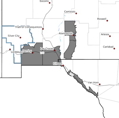
 Southwest Desert/Mimbres Basin-Southern Dona Ana County/Mesilla
Valley-East Central Tularosa Basin/Alamogordo-Southeast Tularosa
Basin-Western El Paso County-Rio Grande Valley of Eastern El
Paso/Western Hudspeth Counties-Rio Grande Valley of Eastern
Hudspeth County-
Including the cities of Deming, Fabens, Las Cruces, Holloman AFB,
Sunland Park, Alamogordo, Vado, Downtown El Paso, Tornillo, West
El Paso, Indian Hot Springs, Fort Hancock, Tularosa, Columbus,
Orogrande, and Upper Valley
139 PM MDT Fri Mar 22 2024
...WIND ADVISORY IN EFFECT FROM 7 AM TO 8 PM MDT SUNDAY...
* WHAT...West winds 30 to 40 mph with gusts up to 60 mph expected.
* WHERE...In New Mexico, East Central Tularosa Basin/Alamogordo,
Southeast Tularosa Basin, Southern Dona Ana County/Mesilla Valley,
and Southwest Desert/Mimbres Basin. In Texas, Rio Grande Valley of
Eastern El Paso/Western Hudspeth Counties, Rio Grande Valley of
Eastern Hudspeth County, and Western El Paso County.
* WHEN...From 7 AM to 8 PM MDT Sunday.
* IMPACTS...Gusty winds will blow around unsecured objects. Tree
limbs could be blown down and a few power outages may result.
* ADDITIONAL DETAILS...The greatest threat of reduced visibility
from blowing dust will be along the heavily traveled I-10 corridor
between Lordsburg and El Paso.
PRECAUTIONARY/PREPAREDNESS ACTIONS...
Winds this strong can make driving difficult, especially for high
profile vehicles. Use extra caution.
Secure outdoor objects.