


Weather
Heat Advisory continues until at least 071323
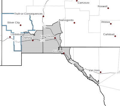 Southwest Desert/Mimbres Basin-Northern Dona Ana County-
Southern Dona Ana County/Mesilla Valley-
Rio Grande Valley of Eastern El Paso/Western Hudspeth Counties-
Rio Grande Valley of Eastern Hudspeth County-
Including the cities of Deming, Columbus, Garfield, Hatch,
Radium Springs, Las Cruces, Vado, Sunland Park, Fabens,
Fort Hancock, Tornillo, and Indian Hot Springs
200 PM MDT Sat Jul 8 2023
...HEAT ADVISORY NOW IN EFFECT THROUGH THURSDAY MORNING...
Heat Advisory 07808-071123
 Southwest Desert/Lower Gila River Valley-Lowlands of the Bootheel-
Uplands of the Bootheel-Sierra County Lakes-
Central Tularosa Basin-Southern Tularosa Basin-Otero Mesa-
Salt Basin-Southern Hudspeth Highlands-
Including the cities of Lordsburg, Red Rock, Virden,
Antelope Wells, Animas, Hachita, Cloverdale,
Truth Or Consequences, Derry, Spaceport, Alamogordo, Tularosa,
White Sands National Park, Chaparral, Orogrande,
White Sands Range Headquarters, Crow Flats, Cornudas, Dell City,
Salt Flat, and Sierra Blanca
231 PM MDT Thu Jul 6 2023
EXTENDED Heat Advisory in effect through 6 am MDT Tuesday 071123
Southwest Desert/Mimbres Basin-Northern Dona Ana County-
Southern Dona Ana County/Mesilla Valley-Western El Paso County-
Eastern/Central El Paso County-
Rio Grande Valley of Eastern El Paso/Western Hudspeth Counties-
Rio Grande Valley of Eastern Hudspeth County-
Including the cities of Deming, Columbus, Garfield, Hatch,
Radium Springs, Las Cruces, Vado, Sunland Park, Downtown El Paso,
West El Paso, Upper Valley, East and Northeast El Paso, Socorro,
Fort Bliss, Fabens, Fort Hancock, Tornillo,
and Indian Hot Springs
1255 PM MDT Wed Jul 5 2023
Dust Advisory 070323
 The National Weather Service in El Paso has issued a
* Dust Advisory for...
Southern Grant County in southwestern New Mexico...
West central Hidalgo County in southwestern New Mexico...
* Until 445 PM MDT.
* At 340 PM MDT, an area of blowing dust was visible on highway
cameras east of Lordsburg. With storms nearby, this area could
easily see visibility drop quickly due to outflow boundaries.
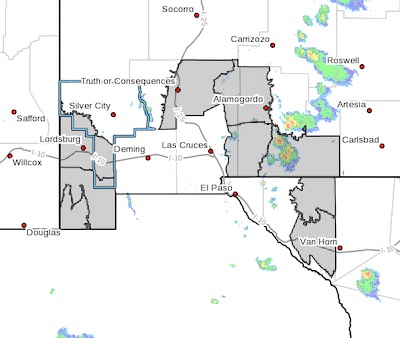
Flood advisory 070323
 FLOOD ADVISORY IN EFFECT UNTIL 430 PM MDT THIS AFTERNOON...
* WHAT...Flooding caused by excessive rainfall is expected.
* WHERE...A portion of southwest New Mexico, including the following
county, Grant.
* WHEN...Until 430 PM MDT.
* IMPACTS...Minor flooding in low-lying and poor drainage areas.
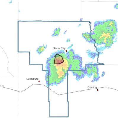
Thunderstorm warning 070323
 Southern Gila Foothills/Mimbres Valley NM-
Southern Gila Highlands/Black Range NM-
Southwest Desert/Lower Gila River Valley NM-
Upper Gila River Valley NM-
216 PM MDT Mon Jul 3 2023
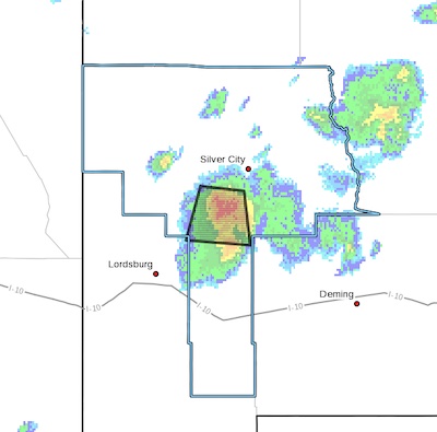
...A strong thunderstorm will impact portions of central Grant and
northern Hidalgo Counties through 245 PM MDT...
At 216 PM MDT, Doppler radar was tracking a strong thunderstorm 5
miles north of White Signal. This storm was nearly stationary.
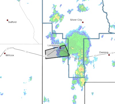
Dust advisory this afternoon on I-10 062723
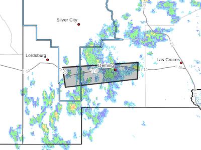 The National Weather Service in El Paso has issued a
* Dust Advisory for...
South central Grant County in southwestern New Mexico...
Central Luna County in southwestern New Mexico...
* Until 600 PM MDT.
* At 500 PM MDT, an area of blowing dust was reported along I-10
near Deming.
HAZARD...Less than one mile visibility with strong
thunderstorm wind gusts to 50 mph.
CANCELED: Heat Advisory Extended 0626-063023 - 2
 Southwest Desert/Lower Gila River Valley-Lowlands of the Bootheel-
Southwest Desert/Mimbres Basin-Northern Dona Ana County-
Central Tularosa Basin-Southern Tularosa Basin-Otero Mesa-
Northern Hudspeth Highlands/Hueco Mountains-
Southern Hudspeth Highlands-
Including the cities of Lordsburg, Red Rock, Virden,
Antelope Wells, Animas, Hachita, Deming, Columbus, Garfield,
Hatch, Radium Springs, Alamogordo, Tularosa,
White Sands National Park, Chaparral, Orogrande,
White Sands Range Headquarters, Crow Flats, Hueco Tanks,
Loma Linda, and Sierra Blanca
626 AM MDT Sun Jun 25 2023
...HEAT ADVISORY NOW IN EFFECT UNTIL MIDNIGHT MDT FRIDAY NIGHT...