


Type 2 Incident Management Team Takes Command of Black Fire
Daily Update 5/18/2022
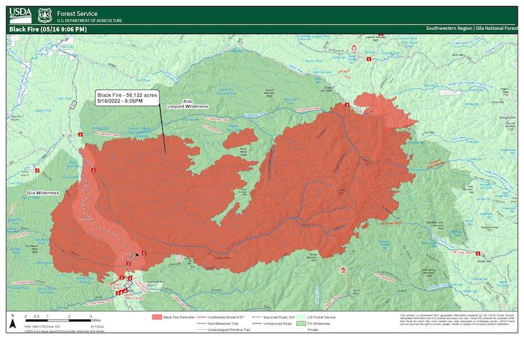
Acres: 77,529 acres (Infrared flight Tuesday night)
Location: 24 miles north of Mimbres
Containment: 0%
Personnel: Over 250, including crews, engines, and support personnel
Start Date: Friday, May 13, 2022
Cause: Unknown, under investigation
Fuels: timber, tall grass
Overview: The Southwest Area Incident Management Team 5, Incident Commander Mark Bernal, assumed command of the Black Fire at 6 a.m. on Wednesday, May 18, 2022.
Fire Update: On Tuesday, the Black Fire showed active fire behavior with short runs and spotting up to a half-mile. On the east side of the fire, hotshot crews, assisted by heavy air tankers, worked in grassy fields and responded to a portion of the fire that began to move to the northwest in the afternoon hours. Ground crews and air tankers worked to construct fireline and tie into Forest Road 150. Also, on Tuesday, a spot fire was observed across Diamond Creek, making an upslope run to the ridge. In addition to actively taking suppression action on the fire, crews began assessing structures, roads, and opportunities to construct indirect lines to contain the fire.
Today, crews will continue conducting structural assessments, assisting landowners with prepping inholdings and scouting roads that help as fuel breaks. Firefighters, including hotshots and other ground crews, will work in on the west side of the fire near Forest Road 150, utilizing direct and indirect tactics. Additionally, aerial resources will provide support pending visibility due to smoke conditions.
Fuels across the fire area have reached record dryness levels due to persistently low relative humidity values and little to no overnight recoveries, resulting in active burning throughout the day and night where fuel, wind, and topography align.
Evacuations: The Sheriffs of Grant, Catron and Sierra counties are using the Ready, Set, Go program to notify residents of evacuation status. For detailed information on Ready, Set, Go! New Mexico visit https://www.emnrd.nm.gov/sfd/fire-prevention-programs/ready-set-go-new-mexico/.
For fire and evacuation maps visit https://inciweb.nwcg.gov/incident/8103/.
In Cooperation with Grant, Catron and Sierra counties the following areas are under evacuation status.
In Grant County:
GO: Starting from the Tom Moore Canyon Trailhead, south two miles, nine miles to the west, and east to the Continental Divide Trail.
SET: Starting from the Tom Moore Canyon Trailhead, three miles south, nine miles to the west, and east to the Continental Divide Trail.
READY: Starting at the Tom Moore Trailhead, south five miles, nine miles to the west, and east to the Continental Divide Trail.
In Catron and Sierra counties.
The area starting at the Grant County line south seven miles south and east to and east from the Continental Divide Trail approximately eight miles:
GO: Starting three miles south of Beaverhead, five miles to the west, south to the Catron and Sierra County line.
SET: From Beaverhead, three miles south to Kemp Mesa, four miles west, six miles east to the Catron County line, and 3 miles north.
Sierra County:
SET: Starting from one mile north of Lookout Mountain Trailhead, north seven miles, west to the Sierra County line and east to County Road 59. Starting from the Sierra County line north 12 miles, three miles east of the Continental Divide Trail, and west four miles. See the included map for details.
Weather: Temperatures will remain above average throughout the week, ranging from the high 70s to the mid-80s. The weather forecast shows light west and southwest winds Wednesday. On Friday, red flag conditions are anticipated with increased winds and persistent low humidity.
Road Closures: Portions of Forest Road 150 (aka North Star Road or Wall Lake Road) is closed to the public.
I-25 and other state highways remain open.
Smoke: The Black Fire produces heavy smoke that can be seen from all over the state. The smoke is drifting to the east affecting much of New Mexico before moving northward into Texas. Visit https://fire.airnow.gov/ for additional information.
Aviation Restrictions: Airtankers and helicopters are available to assist for with fire suppression efforts. There is a Temporary Flight Restriction over the Black Fire. Firefighting aircraft cannot fly if any aircraft, including drones, violates this restriction and poses a danger to firefighters on the ground by leaving them without aerial support.
Fire Restrictions: The New Mexico State Forester has implemented statewide fire restrictions.
More Information
Inciweb: https://inciweb.nwcg.gov/incident/8103/
New Mexico Fire information: https://nmfireinfo.com/