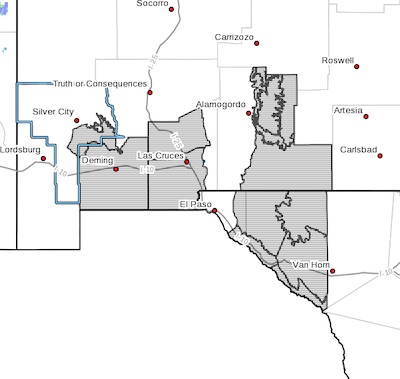
 Southern Gila Foothills/Mimbres Valley-
Southwest Desert/Mimbres Basin-Northern Dona Ana County-
Southern Dona Ana County/Mesilla Valley-
West Slopes Sacramento Mountains Below 7500 Feet-
Sacramento Mountains Above 7500 Feet-
East Slopes Sacramento Mountains Below 7500 Feet-Otero Mesa-
Northern Hudspeth Highlands/Hueco Mountains-Salt Basin-
Southern Hudspeth Highlands-
Rio Grande Valley of Eastern El Paso/Western Hudspeth Counties-
Rio Grande Valley of Eastern Hudspeth County-
Including the cities of Mimbres, Hurley, Faywood,
Grant County Airport, Deming, Columbus, Garfield, Hatch,
Radium Springs, Las Cruces, Vado, Sunland Park, Mescalero,
Timberon, Mountain Park, Cloudcroft, Sunspot, Apache Summit,
Mayhill, Pinon, Sacramento, Crow Flats, Hueco Tanks, Loma Linda,
Cornudas, Dell City, Salt Flat, Sierra Blanca, Fabens,
Fort Hancock, Tornillo, and Indian Hot Springs
134 PM MDT Sat Apr 11 2020
...WIND ADVISORY IN EFFECT FROM 9 AM TO 9 PM MDT SUNDAY...
* WHAT...West winds 25 to 35 mph with gusts up to 40 mph
expected.
* WHERE...Lowlands of southwest and south-central New Mexico along
with the Sacramento Mountains.
* WHEN...From 9 AM to 9 PM MDT Sunday.
* ADDITIONAL DETAILS...Some patchy blowing dust is possible
reducing visibilities to 3 to 5 miles, especially along the I-10
corridor and east of White Sands.
PRECAUTIONARY/PREPAREDNESS ACTIONS...
Use extra caution when driving, especially if operating a high
profile vehicle. Secure outdoor objects.