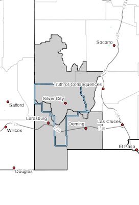
 New Mexico Fire Weather Zone 110
Southwest Mountains/gila Nf/apache Nf/glz-
New Mexico Fire Weather Zone 111
Southwest Deserts and Lowlands/las Cruces Blm/glz-
237 Am Mdt Sun Jun 28 2020
Red Flag Warning Remains in Effect From Noon Today to 8 Pm Mdt
This Evening for Dry and Breezy to Windy Conditions Across
Southwest New Mexico...
Red Flag Warning in Effect From Monday Afternoon Through
Monday Evening for for Dry and Breezy to Windy Conditions Across
Southwest New Mexico...
The National Weather Service in El Paso Tx/Santa Teresa has
issued a Red Flag Warning, which is in effect from noon to 8 PM
MDT this evening. A Fire Weather Watch has also been issued and is
in effect from Monday afternoon through Monday evening.
* AFFECTED AREA...All of New Mexico fire weather zones 110 and
111.
* 20 FT WIND...Southwest winds will increase to 15 to 20 mph
with gusts of 25 to 30 mph through the afternoon and early
evening hours.
* HUMIDITY...Relative humidity will drop to 10 to 14 percent
across the lowlands, and to 14 to 18 percent in the mountains.
* THUNDERSTORMS...There is a slight chance for isolated dry
lightning in the north-central areas of zone 110 on Sunday.
* IMPACTS...Existing fires may exhibit extreme fire behavior and
large growth. Any new fires that develop will likely spread
rapidly. Outdoor burning is not recommended. Be careful of
activities that may produce sparks.
PRECAUTIONARY/PREPAREDNESS ACTIONS...
A Red Flag Warning means that critical fire weather conditions
are either occurring now, or will shortly. A combination of
strong winds, low relative humidity, and warm temperatures can
contribute to extreme fire behavior.
A Fire Weather Watch means that critical fire weather conditions
are forecast to occur. Listen for later forecasts and possible
Red Flag Warnings.