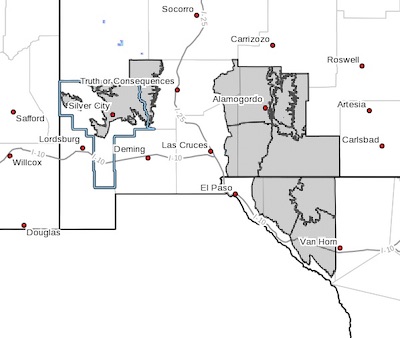
 A Winter Storm System will bring significant amounts of snow to the Sacramento Mountains, portions of Otero and Hudspeth Counties, and the higher elevations of the Black Range... .A winter storm system is expected to move through southern New Mexico and far west Texas tonight through Sunday. This system will bring gusty winds and significant snowfall accumulations. Moderate to heavy snow is possible in those areas with 8 to 12 inches in the Sacramento Mountains, 6 to 9 inches in the Black Range above 7000 feet, 3 to 5 inches for the eastern Tularosa Basin, and 3 to 6 inches across the Otero Mesa and highlands of Hudspeth County. The rest of the lowlands will see light to moderate snowfall with amounts of 1 to 3 inches through Monday morning.
Southern Gila Highlands/Black Range-Central Tularosa Basin-
Southern Tularosa Basin-
West Slopes Sacramento Mountains Below 7500 Feet-
Sacramento Mountains Above 7500 Feet-
East Slopes Sacramento Mountains Below 7500 Feet-Otero Mesa-
Northern Hudspeth Highlands/Hueco Mountains-Salt Basin-
Southern Hudspeth Highlands-
Including the cities of Silver City, Lake Roberts, Alamogordo,
Chaparral, Mescalero, Timberon, Cloudcroft, Mayhill, Pinon,
Sacramento, Crow Flats, Hueco Tanks, Cornudas, Dell City,
Salt Flat, and Sierra Blanca
142 PM MST Sat Feb 13 2021
...WINTER STORM WARNING IN EFFECT FROM 11 PM THIS EVENING TO 5 AM
MST MONDAY...
* WHAT...Heavy snow expected. Total snow accumulations of 8 to 12
inches in the Sacramento Mountains, 6 to 9 inches in the Black
Range, 3 to 5 inches in the Tularosa Basin, and 3 to 6 inches in
Hudspeth County and across the Otero Mesa. Isolated higher
amounts will also be possible over the highest elevations. Winds
gusting as high as 45 mph.
* WHERE...The Sacramento Mountains, the Tularosa Basin, and the
higher elevations of the Gila region and the Black Range in
southern New Mexico. And Hudspeth County in far west Texas.
* WHEN...From 11 PM this evening to 5 AM MST Monday.
* ADDITIONAL DETAILS...Most of the snow accumulation is expected
to occur between 6 AM and 6 PM Sunday. Gusty winds may lead to
blowing snow and whiteout conditions at times. Wind chill values
between -10 and -15 will be possible Sunday night into Monday
morning.
PRECAUTIONARY/PREPAREDNESS ACTIONS...
Travel will be hazardous as roadways become snow-covered and
slick. Some roads may even become impassable in spots. If you must
travel, keep an extra flashlight, food, and water in your vehicle
in case of an emergency. The latest road conditions for the state
you are calling from can be obtained by calling 5 1 1. Wind chill
values will be dangerously cold overnight. Be sure to protect
your pipes, plants, and pets from the extreme cold.