 High Fire Danger Possible Beginning on Tuesday as Southwest Winds Increase During Warm and Dry Weather... .Southwest flow will increase midweek in response to an approaching upper low diving southward along the Pacific coast. Wind speeds will shift to the southwest, becoming windy Tuesday afternoon along with some of the warmest weather so far this year. Relative humidity will dip to 10-15% across the lowland zones (15-25% mountains). Dry fuels will be highly susceptible to ignition and spread. Thus, a fire weather watch has been issued for the southwest New Mexico lowlands. Mountain zones will be slower to reach critical RH due to cooler temperatures, though windy conditions will still present the risk of fire spread. Additional fire weather products may be needed Wed/Thur.\
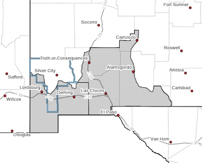
NEW MEXICO FIRE WEATHER ZONE 111
SOUTHWEST DESERTS AND LOWLANDS/LAS CRUCES BLM/GLZ-
NEW MEXICO FIRE WEATHER ZONE 112
SOUTH CENTRAL LOWLANDS AND SOUTHERN RIO GRANDE VALLEY/BLM/GLZ-
201 PM MST Sun Mar 7 2021
...FIRE WEATHER WATCH IN EFFECT FROM TUESDAY AFTERNOON THROUGH
TUESDAY EVENING FOR WINDY CONDITIONS AND LOW RELATIVE
HUMIDITY FOR FIRE WEATHER ZONES 111 AND 112...
The National Weather Service in El Paso Tx/Santa Teresa has
issued a Fire Weather Watch, which is in effect from Tuesday
afternoon through Tuesday evening.
* AFFECTED AREA...Fire weather zone 111 and 112. Including Dona
Ana County and portions of Luna, Otero, Sierra, Grant, and
Hidalgo Counties in southwest New Mexico.
* WIND...Sustained winds from the west-southwest at 20 to 30 mph.
Wind gusts up to 40 mph.
* HUMIDITY...10 to 15 percent.
* IMPACTS...any fires that develop will likely spread rapidly.
Outdoor burning is not recommended.
PRECAUTIONARY/PREPAREDNESS ACTIONS...
A Fire Weather Watch means that critical fire weather conditions
are forecast to occur. Listen for later forecasts and possible
Red Flag Warnings.