 High Fire Danger Likely this Afternoon... .A strong southwest flow at mid levels is allowing an increase in the surface winds over region today. By later morning wind speeds will begin to increase and by afternoon we will see southwest winds of 20 to 30 mph with stronger gusts. Relative humidity will drop to around 8-15% across all the zones this afternoon. Dry fuels will be highly susceptible to ignition and spread. Thus, a Red Flag Warning has been issued for all the zones for this afternoon. Strong winds and dry conditions will continue each day through the weekend into the first of next week.
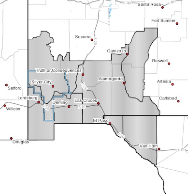
NMZ110>113-TXZ055-056-110200-
/O.EXT.KEPZ.FW.W.0003.210310T1800Z-210311T0200Z/
NEW MEXICO FIRE WEATHER ZONE 110
SOUTHWEST MOUNTAINS/GILA NF/APACHE NF/GLZ-
NEW MEXICO FIRE WEATHER ZONE 111
SOUTHWEST DESERTS AND LOWLANDS/LAS CRUCES BLM/GLZ-
NEW MEXICO FIRE WEATHER ZONE 112
SOUTH CENTRAL LOWLANDS AND SOUTHERN RIO GRANDE VALLEY/BLM/GLZ-
NEW MEXICO FIRE WEATHER ZONE 113
CAPITAN AND SACRAMENTO MOUNTAINS/LINCOLN NF/LNZ-
TEXAS FIRE WEATHER ZONE 055
EL PASO COUNTY-TEXAS FIRE WEATHER ZONE 056
HUDSPETH COUNTY-
346 AM MST Wed Mar 10 2021
...RED FLAG WARNING NOW IN EFFECT FROM 11 AM THIS MORNING TO 7 PM
MST THIS EVENING FOR DRY AND WINDY CONDITIONS...
* AFFECTED AREA...All fire weather for southwest and south central
New Mexico and far west Texas.
* WIND...Sustained winds from the west-southwest at 20 to 30
mph. Wind gusts up to 45 mph.
* HUMIDITY...10 to 15 percent.
* IMPACTS...any fires that develop will likely spread rapidly.
Outdoor burning is not recommended.
PRECAUTIONARY/PREPAREDNESS ACTIONS...
A Red Flag Warning means that critical fire weather conditions
are either occurring now, or will shortly. A combination of
strong winds, low relative humidity, and warm temperatures can
contribute to extreme fire behavior.