 CRITICAL FIRE CONDITIONS EXPECTED THURSDAY AFTERNOON... .West winds will increase mid to late afternoon on Thursday across most of southern New Mexico as surface low pressure develops over northeast New Mexico, but the strongest winds are expected across the lowlands mainly from the Rio Grande Valley west. Combined with very low relative humidities, critical fire conditions are likely. Winds will also increase over zone 110, but at this time look to remain just below criteria.
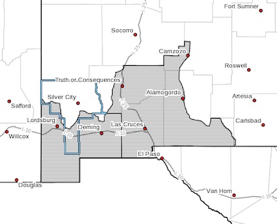
NEW MEXICO FIRE WEATHER ZONE 111
SOUTHWEST DESERTS AND LOWLANDS/LAS CRUCES BLM/GLZ-
NEW MEXICO FIRE WEATHER ZONE 112
SOUTH CENTRAL LOWLANDS AND SOUTHERN RIO GRANDE VALLEY/BLM/GLZ-
323 AM MDT Wed Apr 7 2021
RED FLAG WARNING IN EFFECT FROM 2 PM TO 10 PM MDT THURSDAY FOR
STRONG WINDS AND LOW RELATIVE HUMIDITY...
The National Weather Service in El Paso Tx/Santa Teresa has
issued a Red Flag Warning, which is in effect from 2 PM to 10 PM
MDT Thursday.
* AFFECTED AREA...Fire weather zone 111. Fire weather zone 112
mainly west of the Organ and San Andres Mountains.
* WIND...West winds 20 to 30 mph.
* HUMIDITY...5 to 11 percent.
* IMPACTS...any fires that develop will likely spread rapidly.
Outdoor burning is not recommended.
* HIGHEST THREAT...is located over Luna and Hidalgo counties late
in the afternoon.
PRECAUTIONARY/PREPAREDNESS ACTIONS...
A Red Flag Warning means that critical fire weather conditions
are either occurring now, or will shortly. A combination of
strong winds, low relative humidity, and warm temperatures can
contribute to extreme fire behavior.