 CRITICAL FIRE CONDITIONS EXPECTED THURSDAY AFTERNOON... .West winds will increase mid to late afternoon on Thursday across most of southern New Mexico and far west Texas as surface low pressure develops over northeast New Mexico, but the strongest winds are expected across the lowlands mainly from the Rio Grande west. Combined with very low relative humidities, critical fire conditions are likely
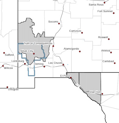
NEW MEXICO FIRE WEATHER ZONE 110
SOUTHWEST MOUNTAINS/GILA NF/APACHE NF/GLZ-
TEXAS FIRE WEATHER ZONE 055
EL PASO COUNTY-TEXAS FIRE WEATHER ZONE 056
HUDSPETH COUNTY-
200 PM MDT Wed Apr 7 2021
...RED FLAG WARNING IN EFFECT FROM 2 PM TO 10 PM MDT THURSDAY FOR
STRONG WINDS AND LOW RELATIVE HUMIDITY...
The National Weather Service in El Paso Tx/Santa Teresa has
issued a Red Flag Warning, which is in effect from 2 PM to 10 PM
MDT Thursday.
* AFFECTED AREA...Fire weather zone 110. Fire weather zone
055. Fire weather zone 056.
* WIND...West at 20 to 25 mph.
* HUMIDITY...5 to 11 percent.
* HIGHEST THREAT...is located along eastern mountain slopes of the
Franklin and Organ Mountains in the late afternoon and early
evening.
* IMPACTS...any fires that develop will likely spread rapidly.
Outdoor burning is not recommended.
PRECAUTIONARY/PREPAREDNESS ACTIONS...
A Red Flag Warning means that critical fire weather conditions
are either occurring now, or will shortly. A combination of
strong winds, low relative humidity, and warm temperatures can
contribute to extreme fire behavior.