 CRITICAL FIRE CONDITIONS EXPECTED TODAY AND TOMORROW... .Southwesterly winds will increase across southern New Mexico the next two afternoons as surface low pressure develops over the state. Gusty winds combined with relative humidities of 6 to 12 percent will create critical fire conditions in southwestern New Mexico this afternoon, and all of southern New Mexico Thursday afternoon.
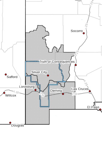
NEW MEXICO FIRE WEATHER ZONE 110
SOUTHWEST MOUNTAINS/GILA NF/APACHE NF/GLZ-
NEW MEXICO FIRE WEATHER ZONE 111
SOUTHWEST DESERTS AND LOWLANDS/LAS CRUCES BLM/GLZ-
631 AM MDT Wed Apr 14 2021
...RED FLAG WARNING IN EFFECT FROM 2 PM THIS AFTERNOON TO 8 PM
MDT THIS EVENING FOR VERY DRY AND WINDY CONDITIONS FOR FIRE
WEATHER ZONES 110 AND 111...
...FIRE WEATHER WATCH REMAINS IN EFFECT FROM THURSDAY AFTERNOON
THROUGH THURSDAY EVENING FOR VERY DRY AND WINDY CONDITIONS FOR
FIRE WEATHER ZONES 110 AND 111...
The National Weather Service in El Paso Tx/Santa Teresa has
issued a Red Flag Warning, which is in effect from 2 PM this
afternoon to 8 PM MDT this evening.
* AFFECTED AREA...Fire weather zones 110 and 111 in southwest New
Mexico.
* WIND...Southwest winds 20 to 25 mph.
* HUMIDITY...6 to 12 percent.
* IMPACTS...Any fires that develop or are ongoing will likely
spread rapidly. Outdoor burning is not recommended.
PRECAUTIONARY/PREPAREDNESS ACTIONS...
A Fire Weather Watch means that critical fire weather conditions
are forecast to occur. Listen for later forecasts and possible
Red Flag Warnings.
A Red Flag Warning means that critical fire weather conditions
are either occurring now, or will shortly. A combination of
strong winds, low relative humidity, and warm temperatures can
contribute to extreme fire behavior.