 NEAR CRITICAL TO CRITICAL FIRE CONDITIONS FOR MONDAY... .Very dry air with Minimum RH values in the single digits, ongoing drought conditions, and winds around 20 MPH will create high to very high fire danger for portions of southwest and south central New Mexico.
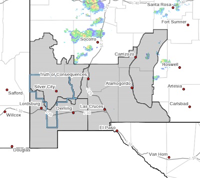
RED FLAG WARNING IN EFFECT FROM 2 PM TO 8 PM MDT MONDAY FOR
VERY DRY CONDITIONS AND GUSTY WINDS FOR NEW MEXICO FIRE WEATHER
ZONES 110, 111, 112, AND 113...
The National Weather Service in El Paso Tx/Santa Teresa has
issued a Red Flag Warning, which is in effect from 2 PM to 8 PM MDT Monday.
* AFFECTED AREA... Southwest and South Central New Mexico
including Fire weather zones 110, 111, 112, and 113.
* WIND...20 to 25 MPH with gusts 30 to 35 MPH.
* HUMIDITY...5 to 15 percent
* HIGHEST THREAT...is located across portions of the Bootheel,
Rio Grande Valley, and Northern Lincoln National Forest.
* IMPACTS...any fires that develop will likely spread rapidly.
Outdoor burning is not recommended.
PRECAUTIONARY/PREPAREDNESS ACTIONS...
A Red Flag Warning means that critical fire weather conditions
are either occurring now, or will shortly. A combination of
strong winds, low relative humidity, and warm temperatures can
contribute to extreme fire behavior.