flash flood watch extended 070121
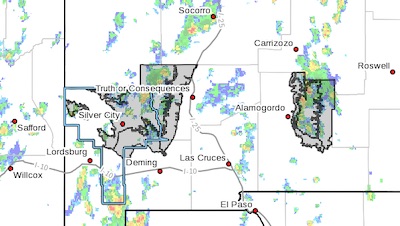
Heavy Rain Threat Continues in Area Mountains Through This Evening... .Showers and thunderstorms will develop once again this afternoon as a more monsoon-like pattern gets established. While locally heavy rain is possible areawide, the greatest threat for flash flooding will be over the Sacramento Mountains and the Gila region.

Southern Gila Highlands/Black Range-
Southern Gila Foothills/Mimbres Valley-
Eastern Black Range Foothills-
West Slopes Sacramento Mountains Below 7500 Feet-
Sacramento Mountains Above 7500 Feet-
East Slopes Sacramento Mountains Below 7500 Feet-
Including the cities of Silver City, Lake Roberts, Kingston,
Fort Bayard, Mimbres, Hurley, Faywood, Grant County Airport,
Hillsboro, Winston, Mescalero, Timberon, Mountain Park,
Cloudcroft, Sunspot, Apache Summit, Mayhill, Pinon,
and Sacramento
127 PM MDT Thu Jul 1 2021

...FLASH FLOOD WATCH NOW IN EFFECT UNTIL MIDNIGHT MDT TONIGHT...

The Flash Flood Watch is now in effect for

* Portions of south central New Mexico and southwest New Mexico,
including the following areas, in south central New Mexico,
East Slopes Sacramento Mountains Below 7500 Feet, Sacramento
Mountains Above 7500 Feet, and West Slopes Sacramento
Mountains Below 7500 Feet. In southwest New Mexico, Eastern
Black Range Foothills, Southern Gila Foothills/Mimbres Valley,
and Southern Gila Highlands/Black Range.

* Until midnight MDT tonight

* Additional showers and thunderstorms are likely over the
Sacramento Mountains, Black Range, and Gila Wilderness this
afternoon and evening. Heavy rains are possible across areas
where the soil is saturated. As a result any significant
rainfall across these areas could lead to additional flash
flooding today.

* Areas that have already received heavy rainfall will be
particularly prone to flash flooding, including the east
slopes of the Sacramento Mountains.

PRECAUTIONARY/PREPAREDNESS ACTIONS...

A Flash Flood Watch means that conditions may develop that lead
to Flash Flooding. Flash Flooding is a very dangerous situation.
You should monitor later forecasts and be prepared to take action
should Flash Flood Warnings be issued.

Do not enter or cross flowing water or water of unknown depth.

Stay away or be swept away. River banks and culverts can become
unstable and unsafe.

Content on the Beat

WARNING: All articles and photos with a byline or photo credit are copyrighted to the author or photographer. You may not use any information found within the articles without asking permission AND giving attribution to the source. Photos can be requested and may incur a nominal fee for use personally or commercially.

Disclaimer: If you find errors in articles not written by the Beat team but sent to us from other content providers, please contact the writer, not the Beat. For example, obituaries are always provided by the funeral home or a family member. We can fix errors, but please give details on where the error is so we can find it. News releases from government and non-profit entities are posted generally without change, except for legal notices, which incur a small charge.

NOTE: If an article does not have a byline, it was written by someone not affiliated with the Beat and then sent to the Beat for posting.

Images: We have received complaints about large images blocking parts of other articles. If you encounter this problem, click on the title of the article you want to read and it will take you to that article's page, which shows only that article without any intruders. 

New Columnists: The Beat continues to bring you new columnists. And check out the old faithfuls who continue to provide content.

Newsletter: If you opt in to the Join GCB Three Times Weekly Updates option above this to the right, you will be subscribed to email notifications with links to recently posted articles.

Submitting to the Beat

Those new to providing news releases to the Beat are asked to please check out submission guidelines at https://www.grantcountybeat.com/about/submissions. They are for your information to make life easier on the readers, as well as for the editor.

Advertising: Don't forget to tell advertisers that you saw their ads on the Beat.

Classifieds: We have changed Classifieds to a simpler option. Check periodically to see if any new ones have popped up. Send your information to editor@grantcountybeat.com and we will post it as soon as we can. Instructions and prices are on the page.

Editor's Notes

It has come to this editor's attention that people are sending information to the Grant County Beat Facebook page. Please be aware that the editor does not regularly monitor the page. If you have items you want to send to the editor, please send them to editor@grantcountybeat.com. Thanks!

Here for YOU: Consider the Beat your DAILY newspaper for up-to-date information about Grant County. It's at your fingertips! One Click to Local News. Thanks for your support for and your readership of Grant County's online news source—www.grantcountybeat.com

Feel free to notify editor@grantcountybeat.com if you notice any technical problems on the site. Your convenience is my desire for the Beat.  The Beat totally appreciates its readers and subscribers!  

Compliance: Because you are an esteemed member of The Grant County Beat readership, be assured that we at the Beat continue to do everything we can to be in full compliance with GDPR and pertinent US law, so that the information you have chosen to give to us cannot be compromised.