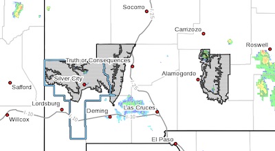
 Upper Gila River Valley-Southern Gila Highlands/Black Range-Eastern
Black Range Foothills-West Slopes Sacramento Mountains Below
7500 Feet-Sacramento Mountains Above 7500 Feet-East Slopes
Sacramento Mountains Below 7500 Feet-
Including the cities of Sunspot, Pinon, Winston, Gila Hot Springs,
Lake Roberts, Sacramento, Timberon, Kingston, Fort Bayard, Silver
City, Mayhill, Buckhorn, Cloudcroft, Mescalero, Mule Creek, Mountain
Park, Hillsboro, Apache Summit, and Cliff
228 AM MDT Sun Jul 18 2021
...FLASH FLOOD WATCH IN EFFECT FROM NOON MDT TODAY THROUGH THIS
EVENING...
The National Weather Service in El Paso Tx/Santa Teresa has issued a
* Flash Flood Watch for portions of south central New Mexico and
southwest New Mexico, including the following areas, in south
central New Mexico, East Slopes Sacramento Mountains Below 7500
Feet, Sacramento Mountains Above 7500 Feet and West Slopes
Sacramento Mountains Below 7500 Feet. In southwest New Mexico,
Eastern Black Range Foothills, Southern Gila Highlands/Black Range
and Upper Gila River Valley.
* From Noon MDT today through this evening.
* Thunderstorms are expected to develop in the early afternoon and
continue into the late evening hours. Local amounts of 1 to 2
inches will be possible resulting in rapid runoff and the
potential for flash flooding. This will be especially true in
areas with repeated rounds of heavy rainfall and below wildfire
burn areas.
PRECAUTIONARY/PREPAREDNESS ACTIONS...
You should monitor later forecasts and be prepared to take action
should Flash Flood Warnings be issued.