 Upper Gila River Valley-Southern Gila Highlands/Black Range-Southern
Gila Foothills/Mimbres Valley-Eastern Black Range Foothills-West
Slopes Sacramento Mountains Below 7500 Feet-Sacramento Mountains
Above 7500 Feet-East Slopes Sacramento Mountains Below 7500 Feet-
Including the cities of Kingston, Gila Hot Springs, Fort Bayard,
Cloudcroft, Hillsboro, Apache Summit, Mayhill, Lake Roberts,
Sacramento, Timberon, Sunspot, Mountain Park, Winston, Cliff, Grant
County Airport, Hurley, Faywood, Buckhorn, Mimbres, Pinon, Silver
City, Mule Creek, and Mescalero
440 AM MDT Sun Aug 29 2021
...FLASH FLOOD WATCH IN EFFECT FROM NOON MDT TODAY THROUGH THIS
EVENING...
The National Weather Service in El Paso Tx/Santa Teresa has issued a
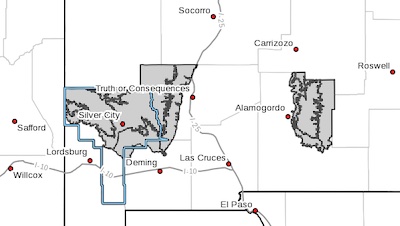
* Flash Flood Watch for portions of south central New Mexico and
southwest New Mexico, including the following areas, in south
central New Mexico, East Slopes Sacramento Mountains Below 7500
Feet, Sacramento Mountains Above 7500 Feet and West Slopes
Sacramento Mountains Below 7500 Feet. In southwest New Mexico,
Eastern Black Range Foothills, Southern Gila Foothills/Mimbres
Valley, Southern Gila Highlands/Black Range and Upper Gila River
Valley.
* From Noon MDT today through this evening.
* Increasing Gulf moisture is filtering in through the area allowing
for mountain storms this afternoon. Storm motions will be slow and
soils in this region are saturated from previous rainfall. Flash
Flooding is probable in these areas.
PRECAUTIONARY/PREPAREDNESS ACTIONS...
You should monitor later forecasts and be prepared to take action
should Flash Flood Warnings be issued.