 CRITICAL FIRE WEATHER CONDITIONS WEDNESDAY AFTERNOON... .Strong southwest flow ahead of an approaching winter storm to the north will promote windy conditions across southern New Mexico and far west Texas Wednesday afternoon. These winds combined with very dry air and favorable fuel conditions will promote high fire danger. Fire will spread quickly in areas with high grass or brush concentrations, with the worst conditions along the Rio Grande Valley mid-afternoon. Higher moisture and cooler temperatures will lessen fire threats over the high mountain terrain.
1223 PM MST Tue Feb 22 2022
...RED FLAG WARNING IN EFFECT FROM NOON TO 7 PM MST WEDNESDAY FOR
STRONG WINDS AND LOW RELATIVE HUMIDITY FOR FIRE WEATHER ZONES
055, 111, AND 112...
The National Weather Service in El Paso TX/Santa Teresa has
issued a Red Flag Warning, which is in effect from noon to 7 PM
MST Wednesday.
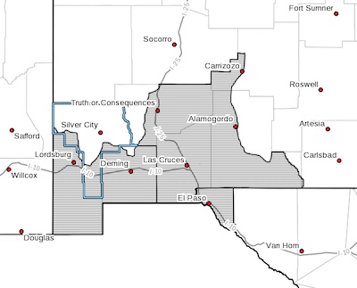
* AFFECTED AREA...Fire weather zones 111 and 112 in southwest and
south-central New Mexico. Fire weather zone 055 in far west
Texas.
* WIND...Southwest winds 25 to 35 mph with gusts up to 50 mph.
* HUMIDITY...8 to 15 percent
* HIGHEST THREAT...is located along the Rio Grande Valley across
Sierra, Dona Ana, and Luna Counties.
* IMPACTS...any fires that develop will likely spread rapidly.
Outdoor burning is not recommended.
PRECAUTIONARY/PREPAREDNESS ACTIONS...
A Red Flag Warning means that critical fire weather conditions
are either occurring now, or will shortly. A combination of
strong winds, low relative humidity, and warm temperatures can
contribute to extreme fire behavior.