fire weather watch 030622

ELEVATED TO NEAR CRITICAL FIRE WEATHER CONDITIONS SUNDAY AFTERNOON... .A weather system passing north of the area on Sunday will generate strong west winds over the area, resulting in wind speeds in the 25 to 35 mph range by the afternoon. Very dry conditions persist with relative humidity values across the desert lowlands to be in the lower to middle teens. These conditions will result in high fire danger that will allow fires to spread quickly. Cooler temperatures behind a passing cold front will slightly lower the threat. Humidity values in the mountains will be higher and will lessen fire danger chances to below critical thresholds. Far western area will also see lower winds and lesser chances for critical fire weather conditions.


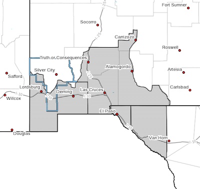
NEW MEXICO FIRE WEATHER ZONE 111
SOUTHWEST DESERTS AND LOWLANDS/LAS CRUCES BLM/GLZ-

NEW MEXICO FIRE WEATHER ZONE 112
SOUTH CENTRAL LOWLANDS AND SOUTHERN RIO GRANDE VALLEY/BLM/GLZ-
TEXAS FIRE WEATHER ZONE 055
EL PASO COUNTY-TEXAS FIRE WEATHER ZONE 056
HUDSPETH COUNTY-
132 PM MST Sat Mar 5 2022

...RED FLAG WARNING IN EFFECT FROM NOON TO 7 PM MST SUNDAY FOR
STRONG WINDS, LOW RELATIVE HUMIDITY, AND HIGH FIRE DANGER...

The National Weather Service in El Paso Tx/Santa Teresa has
issued a Red Flag Warning, which is in effect from noon to 7 PM
MST Sunday.

* AFFECTED AREA...Fire weather zones 111 and 112 in southwest
and south central New Mexico. Fire weather zone 055 and 056 in
far west Texas. Stronger winds and more elevated fire weather
conditions are expected over lowlands east of the Rio Grande
valley.

* WIND...East of the Rio Grande valley, west to southwest winds of
25 to 35 mph with gusts up to 50 mph. West of the Rio Grande
valley, west winds of 15 to 30 mph with gust to 40 mph.

* HUMIDITY...13 to 17 percent

* HIGHEST THREAT...is located across the lowlands east of the Rio
Grande valley, including Hudspeth and Otero counties, where the
relative humidity will be lower, winds will be stronger, and
temperatures will be warmer.

* IMPACTS...any fires that develop will likely spread rapidly.
Outdoor burning is not recommended. Be careful with producing
sparks outdoors.

PRECAUTIONARY/PREPAREDNESS ACTIONS...

A Red Flag Warning means that critical fire weather conditions
are either occurring now, or will shortly. A combination of
strong winds, low relative humidity, and warm temperatures can
contribute to extreme fire behavior.

Content on the Beat

WARNING: All articles and photos with a byline or photo credit are copyrighted to the author or photographer. You may not use any information found within the articles without asking permission AND giving attribution to the source. Photos can be requested and may incur a nominal fee for use personally or commercially.

Disclaimer: If you find errors in articles not written by the Beat team but sent to us from other content providers, please contact the writer, not the Beat. For example, obituaries are always provided by the funeral home or a family member. We can fix errors, but please give details on where the error is so we can find it. News releases from government and non-profit entities are posted generally without change, except for legal notices, which incur a small charge.

NOTE: If an article does not have a byline, it was written by someone not affiliated with the Beat and then sent to the Beat for posting.

Images: We have received complaints about large images blocking parts of other articles. If you encounter this problem, click on the title of the article you want to read and it will take you to that article's page, which shows only that article without any intruders. 

New Columnists: The Beat continues to bring you new columnists. And check out the old faithfuls who continue to provide content.

Newsletter: If you opt in to the Join GCB Three Times Weekly Updates option above this to the right, you will be subscribed to email notifications with links to recently posted articles.

Submitting to the Beat

Those new to providing news releases to the Beat are asked to please check out submission guidelines at https://www.grantcountybeat.com/about/submissions. They are for your information to make life easier on the readers, as well as for the editor.

Advertising: Don't forget to tell advertisers that you saw their ads on the Beat.

Classifieds: We have changed Classifieds to a simpler option. Check periodically to see if any new ones have popped up. Send your information to editor@grantcountybeat.com and we will post it as soon as we can. Instructions and prices are on the page.

Editor's Notes

It has come to this editor's attention that people are sending information to the Grant County Beat Facebook page. Please be aware that the editor does not regularly monitor the page. If you have items you want to send to the editor, please send them to editor@grantcountybeat.com. Thanks!

Here for YOU: Consider the Beat your DAILY newspaper for up-to-date information about Grant County. It's at your fingertips! One Click to Local News. Thanks for your support for and your readership of Grant County's online news source—www.grantcountybeat.com

Feel free to notify editor@grantcountybeat.com if you notice any technical problems on the site. Your convenience is my desire for the Beat.  The Beat totally appreciates its readers and subscribers!  

Compliance: Because you are an esteemed member of The Grant County Beat readership, be assured that we at the Beat continue to do everything we can to be in full compliance with GDPR and pertinent US law, so that the information you have chosen to give to us cannot be compromised.