


 AN EXTENDED PERIOD OF CRITICAL FIRE WEATHER CONDITIONS FOR TODAY THROUGH AT LEAST MONDAY DUE TO STRONG WINDS, VERY LOW HUMIDITY, WARMER THAN NORMAL TEMPERATURES, AND DEEP INSTABILITY... .After a couple of relatively calm days, winds will be on the increase this afternoon. We will see sustained winds of 20 to 30 mph in area mountains and that combined with low min RH's near 10%, has prompted a Red Flag warning to be issued for this afternoon. Most lowland locations will see near Red Flag conditions as well. For Sunday we will see more wide spread windy conditions with very low min RH's, so a Red Flag warning is in effect for both the mountains and the lowlands on Sunday afternoon. Our winds and dry conditions will continue on Monday so a Fire Weather watch has been issued for Monday as well. An approaching upper level storm system will give us even stronger winds on Tuesday.
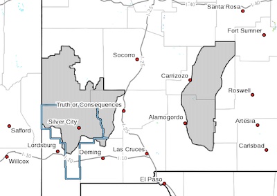
RED FLAG WARNING IN EFFECT FROM 1 PM THIS AFTERNOON TO 7 PM
MDT THIS EVENING FOR STRONG WINDS AND LOW HUMIDITY FOR FIRE
WEATHER ZONES 110 AND 113...
...RED FLAG WARNING IN EFFECT FROM NOON TO 8 PM MDT SUNDAY FOR
STRONG WINDS AND LOW HUMIDITY FOR FIRE WEATHER ZONES 110 AND
113...
...FIRE WEATHER WATCH IN EFFECT FROM MONDAY AFTERNOON
THROUGH MONDAY EVENING FOR STRONG WINDS AND LOW HUMIDITY FOR FIRE
WEATHER ZONES 110 AND 113...
The National Weather Service in El Paso Tx/Santa Teresa has
issued a Red Flag Warning, which is in effect from 1 PM this
afternoon to 7 PM MDT this evening. A Red Flag Warning has also
been issued from noon to 8 PM MDT Sunday. In addition...a Fire
Weather Watch has been issued. This Fire Weather Watch is in
effect from Monday afternoon through Monday evening.
* 20 FOOT WINDS...West to southwest winds will increase to 20 to
30 mph by early afternoon with gusts of 35 to 45 mph after mid
afternoon.
* HUMIDITY...An extended duration of very low relative humidity is
expected. Lowlands will see minimum relative humidity in the
5-10 percent range, while area mountain see minimums in the 8-15
percent range. Overnight recoveries will be poor with maximum
relative humidity only in the 25-40 percent range.
* IMPACTS...any fires that develop will likely spread rapidly.
Outdoor burning is not recommended. Be careful with anything
that might cause sparks.
PRECAUTIONARY/PREPAREDNESS ACTIONS...
A Red Flag Warning means that critical fire weather conditions
are either occurring now, or will shortly. A combination of
strong winds, low relative humidity, and warm temperatures can
contribute to extreme fire behavior.
A Fire Weather Watch means that critical fire weather conditions
are forecast to occur. Listen for later forecasts and possible
Red Flag Warnings.