 CRITICAL FIRE WEATHER CONDITIONS TODAY FOR LOW HUMIDITY AND STRONG WINDS... .Very dry air and breezy west winds will develop on Thursday and continue through the evening hours. Very dry air remains, and thus critical fire weather is expected across much of southwestern and south-central New Mexico in addition to far west Texas. The strongest winds will be west of the Rio Grande Valley. Breezy winds and critically dry fuels will increase the risk for rapid fire spread.
RED FLAG WARNING NOW IN EFFECT FROM NOON TO 8 PM MDT THURSDAY
FOR STRONG WINDS AND LOW HUMIDITY FOR FIRE WEATHER ZONES 055, 056, 110, 111,
112, AND 113...
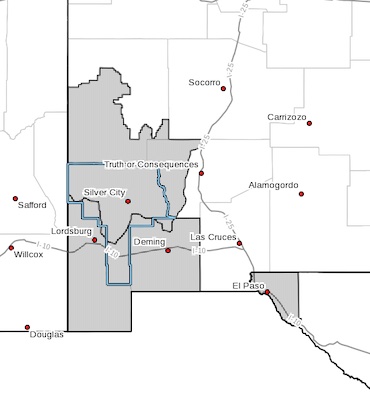
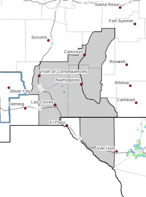
* AFFECTED AREA...Fire weather zone110, 111, 112 and 113 in south-central
and southwest New Mexico. Fire weather zone 055 and 056 in far west
Texas.
* WIND...Southwest winds between 20 and 25 mph.
* HUMIDITY...6 to 13 percent.
The National Weather Service in El Paso Tx/Santa Teresa has
issued a Red Flag Warning, which is in effect from noon to 8 PM
MDT Thursday.
* AFFECTED AREA...Fire weather zone 110, 111, 112, 113 in south-central
and southwest New Mexico. Fire weather zone 055 and 056 in Far West
Texas.
* WIND...Southwest winds between 20 and 25 mph.
* HUMIDITY...6 to 13 percent.
* IMPACTS...any fires that develop will likely spread rapidly.
Outdoor burning is not recommended.
PRECAUTIONARY/PREPAREDNESS ACTIONS...
A Red Flag Warning means that critical fire weather conditions
are either occurring now, or will shortly. A combination of
strong winds, low relative humidity, and warm temperatures can
contribute to extreme fire behavior.