 CRITICAL FIRE WEATHER CONDITIONS TODAY FOR LOW HUMIDITY AND STRONG WINDS... .A very dry airmass continues to stay parked over far west Texas, southwest New Mexico, and south central New Mexico. Above normal temperatures, deep instability, very dry fuels, and increasing winds this afternoon and on Wednesday will all lead to elevated to critical fire weather conditions.
222 PM MDT Mon May 2 2022
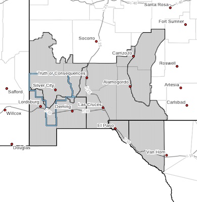
...RED FLAG WARNING REMAINS IN EFFECT UNTIL 8 PM MDT THIS EVENING
FOR LOW HUMIDITY AND STRONG WINDS FOR FIRE WEATHER ZONES 055,
056, 110, 111, 112, AND 113... ...FIRE WEATHER WATCH IN EFFECT
FROM WEDNESDAY AFTERNOON THROUGH WEDNESDAY EVENING FOR LOW
HUMIDITY AND STRONG WINDS FOR FIRE WEATHER ZONES 055, 056, 110,
111, 112, AND 113...
The National Weather Service in El Paso Tx/Santa Teresa has
issued a Fire Weather Watch, which is in effect from Wednesday
afternoon through Wednesday evening.
* AFFECTED AREA...Fire weather zone 110, 111, 112, 113, 055, and
056 which includes far west Texas, southwest New Mexico, and
south central New Mexico.
* WIND...West winds between 15 and 25 mph with gusts up to 35
mph.
* HUMIDITY...7 to 15 percent.
* IMPACTS...any fires that develop will likely spread rapidly.
Outdoor burning is not recommended.
PRECAUTIONARY/PREPAREDNESS ACTIONS...
A Red Flag Warning means that critical fire weather conditions
are either occurring now, or will shortly. A combination of
strong winds, low relative humidity, and warm temperatures can
contribute to extreme fire behavior.
A Fire Weather Watch means that critical fire weather conditions
are forecast to occur. Listen for later forecasts and possible
Red Flag Warnings.