 CRITICAL FIRE WEATHER CONDITIONS WEDNESDAY FOR LOW HUMIDITY AND STRONG WINDS... .As a dry airmass persists, and fuels continue to dry out, west winds will strengthen Tuesday and Wednesday afternoon as another system moves over the central Rockies. The strongest winds will be in the Gila Region Tuesday afternoon, with winds elsewhere remaining just under criteria. Critical fire weather conditions could still occasionally be seen in these areas as the air remains dry and fuels continue to dry out. Winds will strengthen area wide Wednesday afternoon with the strongest winds in the higher elevations of Grant, Sierra, and Otero Counties. A cold front will move through the area north to south Wednesday afternoon, bringing with it drier air. Winds will diminish a few hours after sunset both days. Overnight RH recoveries will be decent early Wednesday morning, but will be 10-20% lower early Thursday morning.
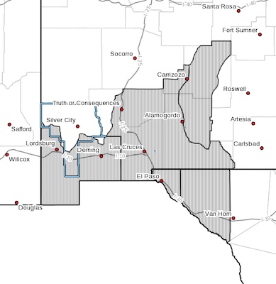
RED FLAG WARNING IN EFFECT FROM NOON TO 7 PM MDT WEDNESDAY FOR
LOW HUMIDITY AND STRONG WINDS FOR FIRE WEATHER ZONES 055, 056,
111, 112, AND 113...
The National Weather Service in El Paso Tx/Santa Teresa has
issued a Red Flag Warning, which is in effect from noon to 7 PM
MDT Wednesday. The Fire Weather Watch is no longer in effect.
* 20 FOOT WINDS...West winds between 15 and 25 mph with gusts up
to 35 mph.
* HUMIDITY...5 to 15 percent.
* IMPACTS...any fires that develop will likely spread rapidly.
Outdoor burning is not recommended.
PRECAUTIONARY/PREPAREDNESS ACTIONS...
A Red Flag Warning means that critical fire weather conditions
are either occurring now, or will shortly. A combination of
strong winds, low relative humidity, and warm temperatures can
contribute to extreme fire behavior.