 CRITICAL FIRE WEATHER CONDITIONS EXPECTED THIS WEEKEND... .Southwest flow restrengthens over the weekend as a surface low develops along the front range of the Southern Rockies. Breezy conditions will begin in the afternoon hours on Saturday. This will be combined with dangerously low humidity and very dry fuel conditions. RH dipping below 8% is expected during the afternoon and evening hours, followed by poor overnight recoveries. Even stronger winds are likely on Sunday, which may create extreme fire danger for much of the area..
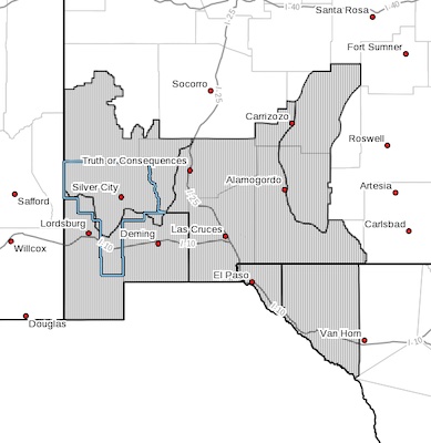
RED FLAG WARNING IN EFFECT FROM NOON TO 9 PM MDT SATURDAY FOR
STRONG WINDS AND VERY LOW HUMIDITY...
...FIRE WEATHER WATCH IN
EFFECT FROM SUNDAY MORNING THROUGH SUNDAY EVENING FOR STRONG WINDS
AND VERY LOW HUMIDITY...
The National Weather Service in El Paso Tx/Santa Teresa has
issued a Red Flag Warning, which is in effect from noon to 9 PM
MDT Saturday. A Fire Weather Watch is also in effect from Sunday
morning through Sunday evening.
* AFFECTED AREA...Southwest and south central New Mexico and far
west Texas
* WIND...15 to 25 mph with gusts to 35 mph.
* HUMIDITY...3 to 8%
* IMPACTS...any fires that develop will likely spread rapidly.
Outdoor burning is not recommended.
PRECAUTIONARY/PREPAREDNESS ACTIONS...
A Red Flag Warning means that critical fire weather conditions
are either occurring now, or will shortly. A combination of
strong winds, low relative humidity, and warm temperatures can
contribute to extreme fire behavior.
A Fire Weather Watch means that critical fire weather conditions
are forecast to occur. Listen for later forecasts and possible
Red Flag Warnings.