. CRITICAL FIRE WEATHER CONDITIONS CONTINUE FOR MONDAY... .Another stronger surface low will form to the north in Colorado today. This will increase southwest winds this afternoon areawide. The windy conditions, extremely low humidity, and very dry fuel conditions will lead to critical fire weather conditions Monday afternoon. Min RH values will dip into the single digits during the afternoon and evening hours. Winds will diminish after sunset this evening. Critical conditions are expected to return Wednesday afternoon for areas west of the Continental Divide (NW FW Zones 110 & 111).
RED FLAG WARNING IN EFFECT FROM NOON TO 8 PM MDT WEDNESDAY FOR
STRONG WINDS AND VERY LOW HUMIDITY...
The National Weather Service in El Paso Tx/Santa Teresa has
issued a Red Flag Warning, which is in effect from noon to 8 PM
MDT Wednesday. The Fire Weather Watch is no longer in effect.
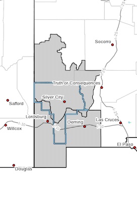
* AFFECTED AREA...Southwest and south-central New Mexico including
fire weather zones 110 through 113.
* WINDS...Southwest 15 to 25 mph with gusts up to 35 mph.
* RELATIVE HUMIDITY...6 to 12 percent.
* IMPACTS...any fires that develop will likely spread rapidly.
Outdoor burning is not recommended.
PRECAUTIONARY/PREPAREDNESS ACTIONS...
A Red Flag Warning means that critical fire weather conditions
are either occurring now, or will shortly. A combination of
strong winds, low relative humidity, and warm temperatures can
contribute to extreme fire behavior.