 CRITICAL FIRE WEATHER CONDITIONS EXPECTED WEDNESDAY... .Upper low over California will progress eastward on Wednesday, with southwest flow aloft ahead of the system generating a lee surface trough over portions of Colorado and New Mexico. Winds will increase during the afternoon hours with sustained speeds of 20 to 25 mph and gusts up to 35 mph. Dry air and above normal temperatures will allow RH to fall to single digits across much of southwest and south-central New Mexico. Near-record low fuel moisture readings will make the risk of new fire starts high.
RED FLAG WARNING IN EFFECT FROM NOON TO 8 PM MDT WEDNESDAY FOR
STRONG WINDS AND VERY LOW HUMIDITY...
The National Weather Service in El Paso Tx/Santa Teresa has
issued a Red Flag Warning, which is in effect from noon to 8 PM
MDT Wednesday.
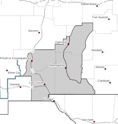
* AFFECTED AREA...Southwest and south-central New Mexico including
fire weather zones 110 through 113.
* WINDS...Southwest 15 to 25 mph with gusts up to 35 mph.
* RELATIVE HUMIDITY...6 to 12 percent.
* IMPACTS...any fires that develop will likely spread rapidly.
Outdoor burning is not recommended.
PRECAUTIONARY/PREPAREDNESS ACTIONS...
A Red Flag Warning means that critical fire weather conditions
are either occurring now, or will shortly. A combination of
strong winds, low relative humidity, and warm temperatures can
contribute to extreme fire behavior.