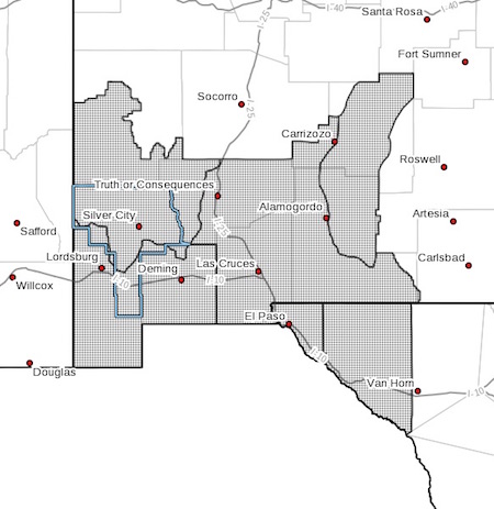
 ...CRITICAL FIRE WEATHER CONDITIONS ARE EXPECTED ON SATURDAY... .An approaching upper level storm system will help create strong and gusty surface winds. When you combine the strong winds with very low RH's, we will see Red Flag conditions across much of southwest and south central New Mexico and far west Texas on Saturday afternoon. We will likely see another day of strong winds and low RH's on Sunday as well.
NMZ110>113-TXZ055-056-262200-
/O.NEW.KEPZ.FW.A.0021.220528T1700Z-220529T0200Z/
NEW MEXICO FIRE WEATHER ZONE 110
SOUTHWEST MOUNTAINS/GILA NF/APACHE NF/GLZ-
NEW MEXICO FIRE WEATHER ZONE 111
SOUTHWEST DESERTS AND LOWLANDS/LAS CRUCES BLM/GLZ-
NEW MEXICO FIRE WEATHER ZONE 112
SOUTH CENTRAL LOWLANDS AND SOUTHERN RIO GRANDE VALLEY/BLM/GLZ-
NEW MEXICO FIRE WEATHER ZONE 113
CAPITAN AND SACRAMENTO MOUNTAINS/LINCOLN NF/LNZ-
TEXAS FIRE WEATHER ZONE 055
EL PASO COUNTY-TEXAS FIRE WEATHER ZONE 056
HUDSPETH COUNTY-
451 AM MDT Thu May 26 2022
...FIRE WEATHER WATCH IN EFFECT FROM SATURDAY MORNING THROUGH
SATURDAY EVENING FOR LOW HUMIDITIES AND STRONG WINDS FOR FIRE
WEATHER ZONES 055, 056, 110, 111, 112, AND 113...
The National Weather Service in El Paso Tx/Santa Teresa has
issued a Fire Weather Watch, which is in effect from Saturday
morning through Saturday evening.
* AFFECTED AREA...For all of southwest and south central New
Mexico and for far west Texas
* WIND...Southwest winds of 15 to 25 mph with gusts up to 35 mph
* HUMIDITY...5 to 10%
* IMPACTS...any fires that develop will likely spread rapidly.
Outdoor burning is not recommended.
PRECAUTIONARY/PREPAREDNESS ACTIONS...
A Fire Weather Watch means that critical fire weather conditions
are forecast to occur. Listen for later forecasts and possible
Red Flag Warnings.