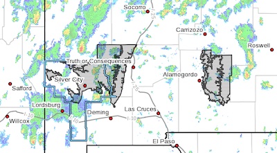
 Southern Gila Highlands/Black Range-Eastern Black Range Foothills-
West Slopes Sacramento Mountains Below 7500 Feet-Sacramento
Mountains Above 7500 Feet-East Slopes Sacramento Mountains Below
7500 Feet-
Including the cities of Sunspot, Pinon, Winston, Mayhill, Lake
Roberts, Sacramento, Timberon, Kingston, Fort Bayard, Silver City,
Cloudcroft, Mescalero, Mountain Park, Hillsboro, and Apache Summit
250 AM MDT Mon Jul 4 2022
...FLOOD WATCH IN EFFECT FROM NOON MDT TODAY THROUGH THIS EVENING...
* WHAT...Flash flooding caused by excessive rainfall is possible.
* WHERE...Portions of south central New Mexico and southwest New
Mexico, including the following areas, in south central New
Mexico, East Slopes Sacramento Mountains Below 7500 Feet,
Sacramento Mountains Above 7500 Feet and West Slopes Sacramento
Mountains Below 7500 Feet. In southwest New Mexico, Eastern Black
Range Foothills and Southern Gila Highlands/Black Range.
* WHEN...From Noon MDT today through this evening.
* IMPACTS...Excessive runoff may result in flooding of rivers,
creeks, streams, and other low-lying and flood-prone locations.
Creeks and streams may rise out of their banks. Low-water
crossings may be flooded.
* ADDITIONAL DETAILS...
- http://www.weather.gov/safety/flood
PRECAUTIONARY/PREPAREDNESS ACTIONS...
You should monitor later forecasts and be prepared to take action
should Flash Flood Warnings be issued.