


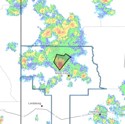
 FLOOD ADVISORY IN EFFECT UNTIL 345 PM MDT THIS AFTERNOON... UNTIL 5 PM TONIGHT WITH IMAGE ON THE RIGHT
* WHAT...Arroyo and small stream flooding caused by excessive
rainfall is expected.
* WHERE...A portion of southwest New Mexico, including the following
county, Grant.
* WHEN...Until 345 PM MDT.
* IMPACTS...Minor flooding in low-lying and poor drainage areas.
* ADDITIONAL DETAILS...
- At 1238 PM MDT, Doppler radar indicated heavy rain due to
thunderstorms. This will cause arroyo and small stream
flooding. Up to 0.5 ito 1.00 inches of rain have fallen.
- Additional rainfall of up to 0.5 inches is expected over the
area. This additional rain will result in minor flooding.
- Some locations that will experience flooding include...
Cooney.
- http://www.weather.gov/safety/flood
PRECAUTIONARY/PREPAREDNESS ACTIONS...
Excessive runoff from heavy rainfall will cause flooding of small
creeks and streams, country roads, farmland, and other low lying
spots.
Remain alert for flooding even in locations not receiving rain.
Arroyos, streams, and rivers can become raging killer currents in a
matter of minutes, even from distant rainfall.
Move away from recently burned areas. Life-threatening flooding of
creeks, roads and normally dry arroyos is likely. The heavy rains
will likely trigger rockslides, mudslides and debris flows in steep
terrain, especially in and around these areas.