flash flood warning 971022Flash Flood Warning
National Weather Service El Paso Tx/Santa Teresa NM
1233 PM MDT Sun Jul 10 2022

The National Weather Service in El Paso Tx/Santa Teresa has issued a

* Flash Flood Warning for...
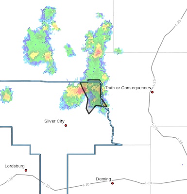
West Central Sierra County in south central New Mexico...
Northeastern Grant County in southwestern New Mexico...

* Until 230 PM MDT.

* At 1233 PM MDT, Doppler radar indicated thunderstorms producing
heavy rain across the warned area. Between 0.8 and 1.2 inches of
rain have fallen. Additional rainfall amounts up to 0.5 inches are
possible in the warned area. Flash flooding is ongoing or expected
to begin shortly.

Excessive rainfall over the burn scar will result in debris flow
moving through the Black Canyon, Upper Mimbres and McKnight Canyon
drainages. The debris flow can consist of rock, mud, vegetation and
other loose materials.

HAZARD...Flash flooding caused by thunderstorms.

SOURCE...Radar.

IMPACT...Flash flooding of small creeks and streams, urban
areas, highways, streets and underpasses as well as
other poor drainage and low-lying areas.

* Some locations that will experience flash flooding include...
Cooney and Upper Mimbres Valley.

PRECAUTIONARY/PREPAREDNESS ACTIONS...

Move away from recently burned areas. Life-threatening flooding of
creeks, roads and normally dry arroyos is likely. The heavy rains
will likely trigger rockslides, mudslides and debris flows in steep
terrain, especially in and around these areas.

Be aware of your surroundings and do not drive on flooded roads.

In hilly terrain there are numerous of low water crossings which are
potentially dangerous in heavy rain. Do not attempt to cross flooded
roads. Find an alternate route.

Remain alert for flooding even in locations not receiving rain.
Arroyos, streams, and rivers can become raging killer currents in a
matter of minutes, even from distant rainfall.

Content on the Beat

WARNING: All articles and photos with a byline or photo credit are copyrighted to the author or photographer. You may not use any information found within the articles without asking permission AND giving attribution to the source. Photos can be requested and may incur a nominal fee for use personally or commercially.

Disclaimer: If you find errors in articles not written by the Beat team but sent to us from other content providers, please contact the writer, not the Beat. For example, obituaries are always provided by the funeral home or a family member. We can fix errors, but please give details on where the error is so we can find it. News releases from government and non-profit entities are posted generally without change, except for legal notices, which incur a small charge.

NOTE: If an article does not have a byline, it was written by someone not affiliated with the Beat and then sent to the Beat for posting.

Images: We have received complaints about large images blocking parts of other articles. If you encounter this problem, click on the title of the article you want to read and it will take you to that article's page, which shows only that article without any intruders. 

New Columnists: The Beat continues to bring you new columnists. And check out the old faithfuls who continue to provide content.

Newsletter: If you opt in to the Join GCB Three Times Weekly Updates option above this to the right, you will be subscribed to email notifications with links to recently posted articles.

Submitting to the Beat

Those new to providing news releases to the Beat are asked to please check out submission guidelines at https://www.grantcountybeat.com/about/submissions. They are for your information to make life easier on the readers, as well as for the editor.

Advertising: Don't forget to tell advertisers that you saw their ads on the Beat.

Classifieds: We have changed Classifieds to a simpler option. Check periodically to see if any new ones have popped up. Send your information to editor@grantcountybeat.com and we will post it as soon as we can. Instructions and prices are on the page.

Editor's Notes

It has come to this editor's attention that people are sending information to the Grant County Beat Facebook page. Please be aware that the editor does not regularly monitor the page. If you have items you want to send to the editor, please send them to editor@grantcountybeat.com. Thanks!

Here for YOU: Consider the Beat your DAILY newspaper for up-to-date information about Grant County. It's at your fingertips! One Click to Local News. Thanks for your support for and your readership of Grant County's online news source—www.grantcountybeat.com

Feel free to notify editor@grantcountybeat.com if you notice any technical problems on the site. Your convenience is my desire for the Beat.  The Beat totally appreciates its readers and subscribers!  

Compliance: Because you are an esteemed member of The Grant County Beat readership, be assured that we at the Beat continue to do everything we can to be in full compliance with GDPR and pertinent US law, so that the information you have chosen to give to us cannot be compromised.