 Southern Gila Highlands/Black Range-Southern Gila Foothills/Mimbres
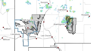
Valley-Eastern Black Range Foothills-West Slopes Sacramento
Mountains Below 7500 Feet-Sacramento Mountains Above 7500 Feet-East
Slopes Sacramento Mountains Below 7500 Feet-
Including the cities of Mountain Park, Apache Summit, Grant County
Airport, Sunspot, Fort Bayard, Hurley, Pinon, Mayhill, Timberon,
Sacramento, Winston, Kingston, Silver City, Faywood, Lake Roberts,
Cloudcroft, Mimbres, Mescalero, and Hillsboro
228 AM MDT Wed Aug 10 2022
...FLOOD WATCH IN EFFECT FROM THURSDAY MORNING THROUGH LATE THURSDAY
NIGHT...
* WHAT...Flash flooding caused by excessive rainfall is possible.
* WHERE...Portions of south central New Mexico and southwest New
Mexico, including the following areas, in south central New
Mexico, East Slopes Sacramento Mountains Below 7500 Feet,
Sacramento Mountains Above 7500 Feet and West Slopes Sacramento
Mountains Below 7500 Feet. In southwest New Mexico, Eastern Black
Range Foothills, Southern Gila Foothills/Mimbres Valley and
Southern Gila Highlands/Black Range.
* WHEN...From Thursday morning through late Thursday night.
* IMPACTS...Excessive runoff may result in flooding of rivers,
creeks, streams, and other low-lying and flood-prone locations.
Flooding may occur in poor drainage and urban areas. Low-water
crossings may be flooded. Heavy rain over burn scars could lead to
flooding and debris flows.
* ADDITIONAL DETAILS...
- http://www.weather.gov/safety/flood
PRECAUTIONARY/PREPAREDNESS ACTIONS...
You should monitor later forecasts and be prepared to take action
should Flash Flood Warnings be issued.