 Southern Gila Highlands/Black Range-
Southern Gila Foothills/Mimbres Valley-
Southwest Desert/Lower Gila River Valley-Lowlands of the Bootheel-
Uplands of the Bootheel-Southwest Desert/Mimbres Basin-
Eastern Black Range Foothills-Sierra County Lakes-
Northern Dona Ana County-Southern Dona Ana County/Mesilla Valley-
Central Tularosa Basin-Southern Tularosa Basin-Otero Mesa-
Western El Paso County-Eastern/Central El Paso County-
Northern Hudspeth Highlands/Hueco Mountains-Salt Basin-
Southern Hudspeth Highlands-
Rio Grande Valley of Eastern El Paso/Western Hudspeth Counties-
Rio Grande Valley of Eastern Hudspeth County-
Including the cities of Silver City, Lake Roberts, Kingston,
Fort Bayard, Mimbres, Hurley, Faywood, Grant County Airport,
Lordsburg, Red Rock, Virden, Antelope Wells, Animas, Hachita,
Cloverdale, Deming, Columbus, Hillsboro, Winston,
Truth Or Consequences, Derry, Spaceport, Garfield, Hatch,
Radium Springs, Las Cruces, Vado, Sunland Park, Alamogordo,
Tularosa, White Sands National Park, Chaparral, Orogrande,
White Sands Range Headquarters, Crow Flats, Downtown El Paso,
West El Paso, Upper Valley, East and Northeast El Paso, Socorro,
Fort Bliss, Hueco Tanks, Loma Linda, Cornudas, Dell City,
Salt Flat, Sierra Blanca, Fabens, Fort Hancock, Tornillo,
and Indian Hot Springs
110 PM MST Sun Dec 11 2022
...WIND ADVISORY IN EFFECT FROM 10 AM TO 11 PM MST MONDAY...
* WHAT...West-southwest winds of 25-35 mph with gusts up to 50
mph. A few isolated gusts may approach 60 mph, especially east
of terrain.
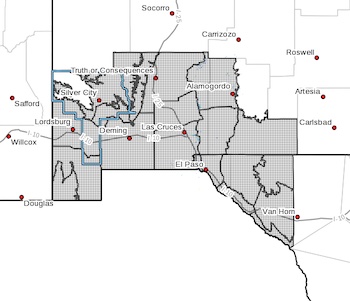
* WHERE...In New Mexico: Hidalgo, Luna, Dona Ana, Sierra, and portions
of Grant and Otero county. In far west Texas: Hudspeth and El
Paso county.
* WHEN...From Monday late morning through Monday evening.
* IMPACTS...Loose objects and decorations may be lofted and damaged.
PRECAUTIONARY/PREPAREDNESS ACTIONS...
A Wind Advisory means that winds of 35 mph are expected. Winds
this strong can make driving difficult, especially for high
profile vehicles. Use extra caution.