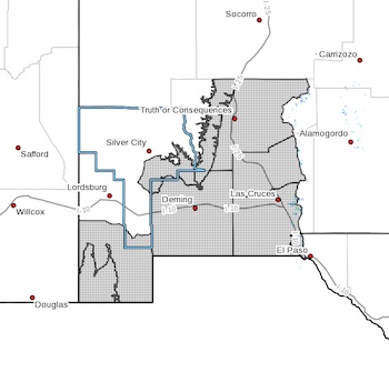
 Southern Gila Foothills/Mimbres Valley-Lowlands of the Bootheel-
Uplands of the Bootheel-Southwest Desert/Mimbres Basin-
Eastern Black Range Foothills-Sierra County Lakes-
Northern Dona Ana County-Southern Dona Ana County/Mesilla Valley-
Western El Paso County-
Including the cities of Mimbres, Hurley, Faywood,
Grant County Airport, Antelope Wells, Animas, Hachita,
Cloverdale, Deming, Columbus, Hillsboro, Winston,
Truth Or Consequences, Derry, Spaceport, Garfield, Hatch,
Radium Springs, Las Cruces, Vado, Sunland Park, Downtown El Paso,
West El Paso, and Upper Valley
157 PM MST Sat Jan 14 2023
...HIGH WIND WARNING IN EFFECT FROM 9 AM TO 8 PM MST SUNDAY...
* WHAT...Southwest winds 30 to 40 mph with gusts up to 60 mph
expected.
* WHERE...In New Mexico, Southern Gila Foothills/Mimbres Valley,
Lowlands of the Bootheel, Uplands of the Bootheel, Southwest
Desert/Mimbres Basin, Eastern Black Range Foothills, Sierra
County Lakes, Northern Dona Ana County and Southern Dona Ana
County/Mesilla Valley Counties. In Texas, Western El Paso
County County.
* WHEN...From 9 AM to 8 PM MST Sunday.
* IMPACTS...Damaging winds could blow down trees and power lines.
Power outages are possible. Travel will be difficult,
especially for high profile vehicles.
* ADDITIONAL DETAILS...Areas of blowing dust are likely, which
could reduce visibility.
PRECAUTIONARY/PREPAREDNESS ACTIONS...
People should avoid being outside in forested areas and around
trees and branches. If possible, remain in the lower levels of
your home during the windstorm, and avoid windows. Use caution if
you must drive.