 Southern Gila Foothills/Mimbres Valley-
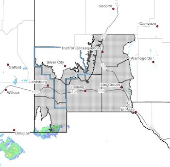
Southwest Desert/Lower Gila River Valley-Lowlands of the Bootheel-
Southwest Desert/Mimbres Basin-Eastern Black Range Foothills-
Sierra County Lakes-Northern Dona Ana County-
Southern Dona Ana County/Mesilla Valley-Western El Paso County-
Including the cities of Mimbres, Hurley, Faywood,
Grant County Airport, Lordsburg, Red Rock, Virden,
Southern Gila Foothills/Mimbres Valley-
Southwest Desert/Lower Gila River Valley-Lowlands of the Bootheel-
Southwest Desert/Mimbres Basin-Eastern Black Range Foothills-
Sierra County Lakes-Northern Dona Ana County-
Southern Dona Ana County/Mesilla Valley-Western El Paso County-
Including the cities of Mimbres, Hurley, Faywood,
Grant County Airport, Lordsburg, Red Rock, Virden,
Antelope Wells, Animas, Hachita, Deming, Columbus, Hillsboro,
Winston, Truth Or Consequences, Derry, Spaceport, Garfield,
Hatch, Radium Springs, Las Cruces, Vado, Sunland Park,
Downtown El Paso, West El Paso, and Upper Valley
353 AM MST Mon Feb 20 2023
...HIGH WIND WATCH IN EFFECT FROM WEDNESDAY MORNING THROUGH
WEDNESDAY EVENING...
* WHAT...Southwest winds 35 to 50 mph with gusts up to 70 mph
possible.
* WHERE...In New Mexico, the lowlands of Hidalgo, Luna, Dona Ana,
and Sierra Counties. In Texas, West El Paso.
* WHEN...From Wednesday morning through Wednesday evening.
* IMPACTS...Damaging winds could blow down trees and power
lines. Widespread power outages are possible. Travel could be
difficult, especially for high profile vehicles.
* ADDITIONAL DETAILS...Very windy conditions will start in the
morning hours with the strongest winds mid-afternoon. Patchy
blowing dust is possible but is not expected to create any major
reductions in visibility. Winds taper off Wednesday evening.
PRECAUTIONARY/PREPAREDNESS ACTIONS...
Monitor the latest forecasts and warnings for updates on this
situation. Fasten loose objects or shelter objects in a safe
location prior to the onset of winds.