Red Flag Warning will be in effect during the afternoon and early evening timeframe on Monday and Tuesday... ..An approaching upper level storm system will bring strong winds to the region Monday and Tuesday. Southwest winds will be 20 to 30 mph with gusts to 40 to 50 mph late Monday morning and into the afternoon then expect west winds of 25 to 40 mph with gusts up to 50 to 60 mph on Tuesday. These strong winds, in combination with min RH's between 5 to 15% will induce critical fire weather conditions. The strong winds will continue into the early evening hours Tuesday, before dropping off a little after sunset
149 PM MDT Sun Apr 2 2023
...RED FLAG WARNING IN EFFECT FROM 10 AM TO 9 PM MDT MONDAY FOR
STRONG WINDS AND DRY CONDITIONS FOR FIRE WEATHER ZONES 055, 056,
110, 111, 112, AND 113...
...RED FLAG WARNING IN EFFECT FROM NOON TO 9 PM MDT TUESDAY FOR
STRONG WINDS AND DRY CONDITIONS FOR FIRE WEATHER ZONES 055, 056,
110, 111, 112, AND 113...
The National Weather Service in El Paso Tx/Santa Teresa has
issued a Red Flag Warning, which is in effect from 10 AM to 9 PM
MDT Monday. a Red Flag Warning has also been issued from noon to
9 PM MDT Tuesday. The Fire Weather Watch is no longer in effect.
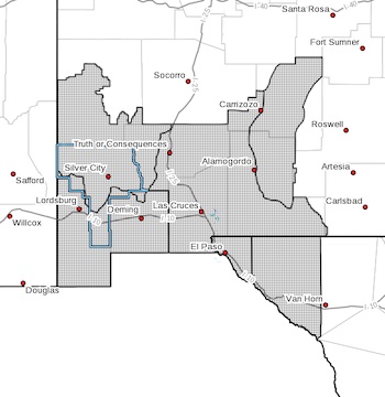
* AFFECTED AREA...Fire weather zones 110, 111, 112, 113 in New
Mexico. Fire weather zones 055 and 056 in Far West Texas.
* WIND...West winds of 20 to 35 mph with gusts near 50 to 60 mph.
* HUMIDITY...5 to 15%
* IMPACTS...Any fires that develop will likely spread rapidly.
Outdoor burning is not recommended.
PRECAUTIONARY/PREPAREDNESS ACTIONS...
A Red Flag Warning means that critical fire weather conditions
are either occurring now, or will shortly. A combination of
strong winds, low relative humidity, a