The Chronicles Of Grant County
Negro Canyon In Grant County
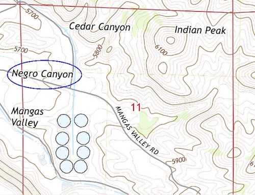 Negro Canyon is located in the Mangas Valley near Cedar Canyon in Grant County. (The topographical map was provided courtesy of the United States Geological Survey, 2019.)
There was a time in American history when a word that is considered by many to be one of the most derogatory words in the English language was used to designate a number of geographic features. That word – "n****r" – is today often abbreviated in this manner to avoid offending people. In years past, though, the name was fully spelled out in official governmental maps to highlight waterbodies, hills, canyons, and other geographic features. The word was also used as a street name in a number of communities in our country.
Grant County was no different from many other places in the United States. The United States Geological Survey (USGS) database of Geographic Names includes details on "Negro Canyon" in Grant County. The canyon is located north of Mangas Valley Road between Tyrone and Burro Peak; it is listed as being at an elevation of 5,643 feet above sea level.
For years, this geographic feature was once known as "N****r Canyon." Why it received this specific name is unknown. The specific year when the name was changed to "Negro Canyon" is uncertain, but may have taken place in the early 1960s. A map from 1950, shown below, includes the former name for this canyon.
It was in 1962 that the Federal government began a full-scale effort to remove this derogatory word as the name of any geographic feature in the United States. On July 27, 1962, Stewart Udall, then the U S Secretary of the Interior, wrote:
"A recent expression of concern about a geographic name including the word 'n****r' [the word was fully spelled in this instance as well as throughout this document] brings into question the propriety of our approach under conditions now prevailing. Surely no one now would suggest a new name including the word, and as surely someone will express concern about any old one that remains.
"Whatever the overtones of the word were in the past, unquestionably a great many people now consider it derogatory or worse. It is like an obscenity in that avoidance of its use is common courtesy and in that its use may incur some sort of social penalty. I do not see how the Federal Government can in conscience require the use of the word in any connection.
"I am aware of the need to discourage attempts by individuals to change perfectly good names for purely personal reasons. However, the attitude toward 'n****r' is broader than personal, and a name can hardly be 'perfectly good' if it contains a word that many people find offensive or will not say out loud."
Beyond the site in Grant County, a number of other geographic features in New Mexico also had previous names using that specific derogatory word. In many cases, the geographic features with the word "n****r" were typically renamed using the word "Negro." Two examples of geographic features in New Mexico that previously included that derogatory word are Negro Mesa near Summit in Union County and Negro Ed Canyon near Valley in Otero County, according to the USGS database of geographic names. In 1968, a newspaper in Alamogordo was still using the former named when referencing an incident that had occurred at Negro Ed Canyon in 1907.
In other communities, new names were utilized to replace the derogatory word. Sometimes, these name changes took place over a period of years.
A geographic feature in Roosevelt County in New Mexico is one such example. The USGS database of geographic names noted that N****r Hill in that county was renamed as "Dead Negro Hill." This hill is located, according to the USGS, 3 miles east-southeast of Lingo and 44 miles south of Clovis; the location is within miles of the state's border with Texas.
On October 12, 2005, the Board [the Board on Geographic Names] approved the renaming of this geographic feature as "Buffalo Soldier Hill." This name was to recognize the Buffalo Soldiers of Troop A of the U S Tenth Cavalry, according to the USGS, who reportedly died near this location in 1877. The Galveston Daily News on August 8, 1877, reported on its front page that "Capt. Nolan [commander of this unit of Buffalo Soldiers] has been heard from. He lost a few men, left dead, and three are missing…They were out eighty-four hours without water, and the suffering was great. Extreme heat continues unabated."
"N****r" is one of three words that the Federal government will not approve to be a name used to designate a geographic feature in the United States. One of the other words – "Jap" – is considered by many to be a derogatory name for people of Japanese heritage. These standards are detailed in "Derogatory Geographic Names Policy and Guidelines" of the United States Board on Geographic Names: "In the case of domestic geographic names, the Board on Geographic Names will not adopt a (locally used) name for Federal usage that is derogatory to a particular ethnic group, religion, or class of people…The [United States] Board [on Geographic Names] will not adopt a name proposal that includes the word "Jap" or the word "N****r" [spelled out fully in the policy guidelines] whether or not it is in current local usage and regardless of by whom proposed."
Through the years, the USGS has considered refusing to name geographic features using other words that are considered derogatory. For a number of years, Native Americans and other Americans have asked for a specific word to be removed from usage in the naming of geographic features. On November 19, 2021, the word "squaw" was declared to be derogatory by the U S Secretary of the Interior. The next edition of The Chronicles Of Grant County will discuss how this recent decision will affect the names of at least two sites in Grant County.
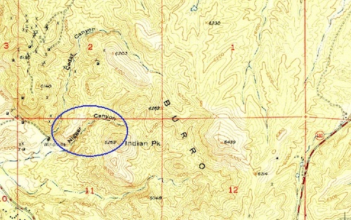 This topographical map shows the former name of what is now known as "Negro Canyon" in Grant County. (The topographical map was provided courtesy of the United States Geological Survey, 1950.)
Do you have questions about communities in Grant County?
A street name? A building?
Your questions may be used in a future news column.
Contact Richard McDonough at chroniclesofgrantcounty@mail.com.
If your email does not go through, please contact editor@grantcountybeat.com.
© 2022 Richard McDonough