The Chronicles Of Grant County
Federal Plans For
Gila Lower Box Area
[Editor's Note: Please see larger version of map as a PDF at the bottom of the article.]
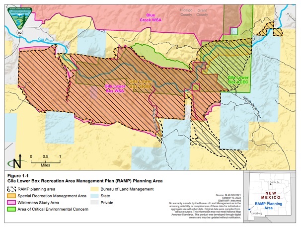 The Gila Lower Box Area includes the area with the diagonal stripes in Grant and Hidalgo Counties. (The map was provided courtesy of the United States Bureau of Land Management, October 10, 2023.)
The United States Bureau of Land Management (BLM) is encouraging the general public to review and comment on its plans for what the BLM calls the "Gila Lower Box Area."
This area includes a portion of northern Hidalgo County as well as a section of southcentral Grant County. The area is located, according to the BLM, approximately 20 miles northwest of Lordsburg. In total, the BLM indicated that the Gila Lower Box Area includes about 11,200 acres.
The BLM has developed a Recreation Area Management Plan (RAMP) for these sections of Grant and Hidalgo Counties.
"The plan will guide future development and provide management direction for recreation resources within the Gila Lower Box Area," noted the BLM in a recent news statement. "There is a need to implement primitive and sustainable recreation actions to protect the Gila Lower Box Area while being consistent with the management goal of protecting riparian values outlined in the 1993 Mimbres Resource Management Plan."
"The planning area is characterized by cliffs and steep canyon sides rising above a significant riparian area," the BLM news statement continued. "The area is home to several threatened, endangered, and sensitive wildlife species as well as designated critical habitat for these species. The area also provides important habitat to a variety of native plants and wildlife. While recreation is an important use of the planning area, unmanaged recreation use has resulted in disturbance and damage to sensitive resources."
The 220-page document detailing this plan for the Gila Lower Box Area can be viewed at https://eplanning.blm.gov/public_projects/2018358/200517550/20108446/251008446/Gila%20Lower%20Box_RAMP_EA.pdf.
The BLM stated that the public is encouraged to review the final documents and provide comments or concerns prior to 5:00 PM (MST) on May 16.
"All comments received will be fully considered and evaluated," the BLM indicated in its news statement. "To review documents and provide comments, please visit BLM's ePlanning website at https://eplanning.blm.gov/eplanning-ui/project/2018358/510."
People can also send comments through the postal mail to Bureau of Land Management, Las Cruces District Office, Attn: Allie Bettinger, Gila Lower Box
RAMP, 1800 Marquess Street, Las Cruces, NM 88005.
"This plan proposes to improve and enhance recreational experiences in the Gila Lower Box Area and protect cultural and biological resources," said Dave Wallace, Assistant Manager for Multi-Resources in the Las Cruces District of BLM. "This will be completed by creating and implementing recreation infrastructure that meets the primitive recreational values of the area."
Do you have questions about communities in Grant County?
A street name? A building?
Your questions may be used in a future news column.
Contact Richard McDonough at chroniclesofgrantcounty@mail.com.
If your email does not go through, please contact editor@grantcountybeat.com.
© 2024 Richard McDonough