 Upper Gila River Valley-Southern Gila Highlands/Black Range-
Southern Gila Foothills/Mimbres Valley-
Southwest Desert/Lower Gila River Valley-Lowlands of the Bootheel-
Uplands of the Bootheel-Southwest Desert/Mimbres Basin-
Eastern Black Range Foothills-Sierra County Lakes-
Northern Dona Ana County-Southern Dona Ana County/Mesilla Valley-
Central Tularosa Basin-Southern Tularosa Basin-
West Slopes Sacramento Mountains Below 7500 Feet-
Sacramento Mountains Above 7500 Feet-
East Slopes Sacramento Mountains Below 7500 Feet-Otero Mesa-
Western El Paso County-Eastern/Central El Paso County-
Northern Hudspeth Highlands/Hueco Mountains-
Rio Grande Valley of Eastern El Paso/Western Hudspeth Counties-
Including the cities of Cliff, Buckhorn, Gila Hot Springs,
Mule Creek, Silver City, Lake Roberts, Kingston, Fort Bayard,
Mimbres, Hurley, Faywood, Grant County Airport, Lordsburg,
Red Rock, Virden, Antelope Wells, Animas, Hachita, Cloverdale,
Deming, Columbus, Hillsboro, Winston, Truth Or Consequences,
Derry, Spaceport, Garfield, Hatch, Radium Springs, Las Cruces,
Vado, Sunland Park, Alamogordo, Tularosa, White Sands Monument,
Chaparral, Orogrande, White Sands Range Headquarters, Mescalero,
Timberon, Mountain Park, Cloudcroft, Sunspot, Apache Summit,
Mayhill, Pinon, Sacramento, Crow Flats, Downtown El Paso,
West El Paso, Upper Valley, East and Northeast El Paso, Socorro,
Fort Bliss, Hueco Tanks, Loma Linda, Fabens, Fort Hancock,
and Tornillo
1056 AM MDT Fri Jul 24 2020
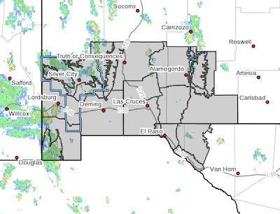
...FLASH FLOOD WATCH IN EFFECT THROUGH LATE TONIGHT...
The National Weather Service in El Paso Tx/Santa Teresa has
issued a
* Flash Flood Watch for portions of New Mexico and southwest
Texas, including the following areas, in New Mexico, Central
Tularosa Basin, East Slopes Sacramento Mountains Below 7500
Feet, Eastern Black Range Foothills, Lowlands of the Bootheel,
Northern Dona Ana County, Otero Mesa, Sacramento Mountains
Above 7500 Feet, Sierra County Lakes, Southern Dona Ana
County/Mesilla Valley, Southern Gila Foothills/Mimbres Valley,
Southern Gila Highlands/Black Range, Southern Tularosa Basin,
Southwest Desert/Lower Gila River Valley, Southwest
Desert/Mimbres Basin, Uplands of the Bootheel, Upper Gila
River Valley, and West Slopes Sacramento Mountains Below 7500
Feet. In southwest Texas, Eastern/Central El Paso County,
Northern Hudspeth Highlands/Hueco Mountains, Rio Grande Valley
of Eastern El Paso/Western Hudspeth Counties, and Western El
Paso County.
* Through late tonight
* Moist unstable air will flow into the area resulting in numerous
thunderstorms across the region. A few storms may produce heavy
rains with over 2 inches rain falling over several locations.
* Flash flooding may occur over a few locations especially around
low water crossings...poor drainage areas and along arroyos and
streams. Road closures may be required. Some property may become
damaged if located near high waters.
PRECAUTIONARY/PREPAREDNESS ACTIONS...
A Flash Flood Watch means that conditions may develop that lead
to flash flooding. Flash flooding is a VERY DANGEROUS SITUATION.
You should monitor later forecasts and be prepared to take action
should Flash Flood Warnings be issued.