

 Click to Search
Search
[{{{type}}}] {{{reason}}}
{{/data.error.root_cause}}
{{{_source.title}}} {{#_source.showPrice}} {{{_source.displayPrice}}} {{/_source.showPrice}}
{{#_source.showLink}} {{/_source.showLink}} {{#_source.showDate}}{{{_source.displayDate}}}
{{/_source.showDate}}{{{_source.description}}}
{{#_source.additionalInfo}}{{#_source.additionalFields}} {{#title}} {{{label}}}: {{{title}}} {{/title}} {{/_source.additionalFields}}
{{/_source.additionalInfo}}
Weather
- Category: Weather
ROAD ADVISORY
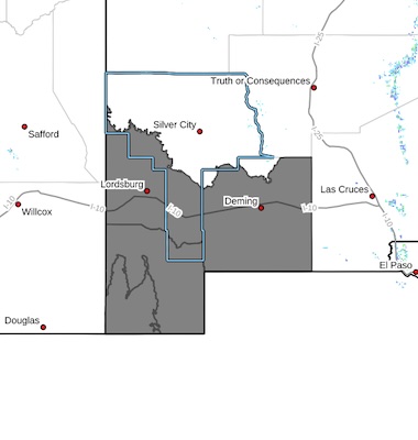
DIFFICULT DRIVING CONDITIONS: Silver City Area
Difficult Driving Conditions, NM 15 northbound and southbound from mile marker 6, 1 mile south of Pinos Altos to mile marker 25, 14 miles south of Gila Hot Springs, roads are icy in spots. Please drive with caution, reduce speed, and obey all posted traffic signs. The NMDOT will continue to monitor roadways. This event will be updated as conditions change.
DIFFICULT DRIVING CONDITIONS: Silver City Area
- Category: Weather
 Southwest Desert/Lower Gila River Valley-Lowlands of the Bootheel-
Uplands of the Bootheel-Southwest Desert/Mimbres Basin-
Including the cities of Antelope Wells, Columbus, Red Rock,
Hachita, Cloverdale, Deming, Virden, Lordsburg, and Animas
1023 AM MST Sat Jan 10 2026
...COLD WEATHER ADVISORY IN EFFECT FROM 11 PM THIS EVENING TO 9 AM MST SUNDAY..
* WHAT...Very cold wind chills of 10 to 15 degrees expected.
* WHERE...Far Southwest New Mexico.
* WHEN...From 11 PM this evening to 9 AM MST Sunday.
* IMPACTS...Frostbite and hypothermia will occur if unprotected skin
is exposed to these temperatures.
- Category: Weather
ROAD ADVISORY
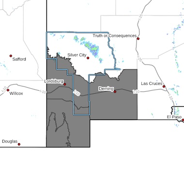
DIFFICULT DRIVING CONDITIONS: Silver City Area
Difficult Driving Conditions, NM 15 northbound and southbound from mile marker 6, 1 mile south of Pinos Altos to mile marker 25, 14 miles south of Gila Hot Springs, roads are slushy, snow packed and icy in spots. Please drive with caution, reduce speed, and obey all posted traffic signs. The NMDOT will continue to monitor roadways. This event will be updated as conditions change.
DIFFICULT DRIVING CONDITIONS: Silver City Area
Difficult Driving Conditions, NM 152 eastbound and westbound from mile marker 23, 8 miles east of San Lorenzo to mile marker 40, Kingston, .roads are slushy, snow packed and icy in spots. Please drive with caution, reduce speed, and obey all posted traffic signs. The NMDOT will continue to monitor roadways. This event will be updated as conditions change.
DIFFICULT DRIVING CONDITIONS: Silver City Area
Difficult Driving Conditions, NM 35 northbound and southbound from mile marker 11, 11 miles north of NM 152 to mile marker 27, 0.5 miles south of NM 15, roads are slushy, snow packed and icy in spots. Please drive with caution, reduce speed, and obey all posted traffic signs. The NMDOT will continue to monitor roadways. This event will be updated as conditions change.
- Category: Weather
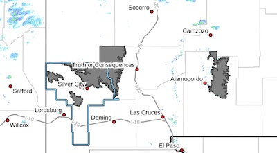
As of 5:42 p.m., NM 15 northbound and southbound from mile marker 15, 8 miles north of Pinos Altos to mile marker 25, 14 miles south of Gila Hot Springs, is open and removed from NMRoads.
CLOSURE: Pinos Altos
Closure, NM 15 northbound and southbound from mile marker 15, 8 miles north of Pinos Altos to mile marker 25, 14 miles south of Gila Hot Springs, is closed due to snowplow stuck on roadway. Please seek alternate route and obey all posted traffic signs. The NMDOT is working on clearing the roadway. This event will be updated as conditions change.
- Category: Weather
 Southwest Desert/Lower Gila River Valley-Lowlands of the Bootheel-
Uplands of the Bootheel-Southwest Desert/Mimbres Basin-
Including the cities of Deming, Antelope Wells, Columbus,
Cloverdale, Red Rock, Animas, Hachita, Lordsburg, and Virden
1012 AM MST Fri Jan 9 2026
...COLD WEATHER ADVISORY IN EFFECT FROM 11 PM THIS EVENING TO 10 AM
MST SATURDAY...
* WHAT...Very cold wind chills of 10 to 15 degrees expected.
* WHERE...Far Southwest New Mexico.
* WHEN...From 11 PM this evening to 10 AM MST Saturday.
* IMPACTS...Frostbite and hypothermia will occur if unprotected skin
is exposed to these temperatures.
- Category: Weather
ROAD ADVISORY
Difficult Driving Conditions: Cliff Area
NM 159 from milepost 5 to 26 is reported as snow-packed and icy. Please drive with caution, reduce speed, and obey all posted traffic signs. The NMDOT is plowing and will continue to monitor roadways. This event will be updated as conditions change.
- Category: Weather
See Full report in PDF format below:
The Grant County Region is still expecting another round of mountain snow later this afternoon into the evening along with some cold weather behind it.
• 1-3" of snow for most locations over 6000'
• Under an inch as low as 5000' for areas near the Gila
• Snow may be moderate to heavy at times producing snow squall conditions
• Bulk of snow will fall from 5-8PM Gila and 9PM-Midnight for the Sacramento Mtns
• Near Zero Wind Chills Friday and Saturday AM for the mountains
• Teens and 20s Wind Chills for the Lowlands Friday and Saturday AM
- Category: Weather
 Highlands/Black Range-
Including the cities of Lake Roberts, Cloudcroft, Kingston,
Sunspot, and Apache Summit
1240 PM MST Thu Jan 8 2026
...COLD WEATHER ADVISORY IN EFFECT FROM 3 AM FRIDAY TO 10 AM MST SATURDAY...
* WHAT...Very cold wind chills around 5 degrees expected.
* WHERE...The Sacramento Mountains above 7500 feet, and the higherelevations of the southern Gila Region, including the Black Range.
* WHEN...From 3 AM Friday to 10 AM MST Saturday.


Content on the Beat
WARNING: All articles and photos with a byline or photo credit are copyrighted to the author or photographer. You may not use any information found within the articles without asking permission AND giving attribution to the source. Photos can be requested and may incur a nominal fee for use personally or commercially.
Disclaimer: If you find errors in articles not written by the Beat team but sent to us from other content providers, please contact the writer, not the Beat. For example, obituaries are always provided by the funeral home or a family member. We can fix errors, but please give details on where the error is so we can find it. News releases from government and non-profit entities are posted generally without change, except for legal notices, which incur a small charge.
NOTE: If an article does not have a byline, it was written by someone not affiliated with the Beat and then sent to the Beat for posting.
Images: We have received complaints about large images blocking parts of other articles. If you encounter this problem, click on the title of the article you want to read and it will take you to that article's page, which shows only that article without any intruders.
New Columnists: The Beat continues to bring you new columnists. And check out the old faithfuls who continue to provide content.
Newsletter: If you opt in to the Join GCB Three Times Weekly Updates option above this to the right, you will be subscribed to email notifications with links to recently posted articles.
Editor's Notes
It has come to this editor's attention that people are sending information to the Grant County Beat Facebook page. Please be aware that the editor does not regularly monitor the page. If you have items you want to send to the editor, please send them to editor@grantcountybeat.com. Thanks!
Here for YOU: Consider the Beat your DAILY newspaper for up-to-date information about Grant County. It's at your fingertips! One Click to Local News. Thanks for your support for and your readership of Grant County's online news source—www.grantcountybeat.com
Feel free to notify editor@grantcountybeat.com if you notice any technical problems on the site. Your convenience is my desire for the Beat. The Beat totally appreciates its readers and subscribers!
Compliance: Because you are an esteemed member of The Grant County Beat readership, be assured that we at the Beat continue to do everything we can to be in full compliance with GDPR and pertinent US law, so that the information you have chosen to give to us cannot be compromised.
Submitting to the Beat
Those new to providing news releases to the Beat are asked to please check out submission guidelines at https://www.grantcountybeat.com/about/submissions. They are for your information to make life easier on the readers, as well as for the editor.
Advertising: Don't forget to tell advertisers that you saw their ads on the Beat.
Classifieds: We have changed Classifieds to a simpler option. Check periodically to see if any new ones have popped up. Send your information to editor@grantcountybeat.com and we will post it as soon as we can. Instructions and prices are on the page.