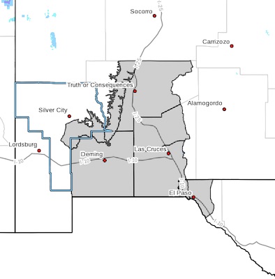
 Southern Gila Foothills/Mimbres Valley-
Southwest Desert/Mimbres Basin-Eastern Black Range Foothills-
Sierra County Lakes-Northern Dona Ana County-
Southern Dona Ana County/Mesilla Valley-Western El Paso County-
Eastern/Central El Paso County-
Including the cities of Mimbres, Hurley, Faywood,
Grant County Airport, Deming, Columbus, Hillsboro, Winston,
Truth Or Consequences, Derry, Spaceport, Garfield, Hatch,
Radium Springs, Las Cruces, Vado, Sunland Park, Downtown El Paso,
West El Paso, Upper Valley, East and Northeast El Paso, Socorro,
and Fort Bliss
411 AM MST Sat Feb 13 2021
...Winter Storm remains on track to bring accumulating snowfall and much colder temperatures...
A winter storm is expected to arrive from the northwest on Sunday
morning while cold, arctic air is expected to move east
throughout the day on Sunday. To the west of this front, all
precipitation will be rain while to the east, snow. Precipitation
looks to be ongoing with the passage of the front with
temperatures quickly falling behind it, which presently looks to
occur around mid-day or early afternoon. Up to 2 inches looks
possible for much of the Rio Grande Valley. The timing of the
frontal passage along with when precipitation ends remains
uncertain. A quicker cold front passage and a slower precipitation
departure could yield higher amounts of snowfall and vice versa.
Either way, wet roadways will quickly freeze during the afternoon
and evening with slick spots possible. Plan on travel impacts for
Sunday afternoon into Monday morning. In addition to snow,
temperatures will be the coldest so far this season, with many
lowland locations dropping into the teens and single digits by
Sunday evening with wind chill values near zero. Protect people,
pets, pipes, and plants.