 ...Another winter storm will impact the Sacramento Mountains and the Black Range on Tuesday... .Another winter storm system will be moving through southern New Mexico on Tuesday. This system brings additional snowfall accumulations to the Gila region including the Black Range, and the Sacramento Mountains. Periods of heavy snow will be likely in those areas. Gusty winds are also possible with this system which may cause whiteout conditions. The precipitation associated to this system is expected to leave the area by Wednesday morning. However, we will continue to experience cold temperatures through Thursday, as the system lingers in the region
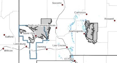
Southern Gila Highlands/Black Range-
West Slopes Sacramento Mountains Below 7500 Feet-
Sacramento Mountains Above 7500 Feet-
East Slopes Sacramento Mountains Below 7500 Feet-
Including the cities of Silver City, Lake Roberts, Mescalero,
Timberon, Cloudcroft, Mayhill, and Sacramento
239 PM MST Mon Feb 15 2021
...WINTER WEATHER ADVISORY IN EFFECT FROM 5 AM TUESDAY TO 5 AM
MST WEDNESDAY...
* WHAT...Snow expected. Total snow accumulations between 3 to 6
inches with isolated amounts up to 8 inches in the highest
peaks of mountains. Winds gusting as high as 35 mph.
* WHERE...The Sacramento Mountains in south central New Mexico and
the Gila Region including the Black Range in southwestern New
Mexico.
* WHEN...From 5 AM Tuesday to 5 AM MST Wednesday.
* ADDITIONAL DETAILS...The strongest bands with heavy snow are
expected on Tuesday between the late morning and the afternoon.
Gusty winds may lead to blowing snow which will reduce the
visibilities.
PRECAUTIONARY/PREPAREDNESS ACTIONS...
Slow down and use caution while traveling.
The latest road conditions for the state you are calling from can
be obtained by calling 5 1 1.