CRITICAL FIRE CONDITIONS POSSIBLE ON SUNDAY... .A potent upper level system will combine with a strong surface system to produce gusty winds across the region. Windy and very dry conditions will make for critical fire weather on Sunday across all of south central New Mexico and Far West Texas. Winds of 20 to 25 mph with gusts 35 to 40 mph and min RH values near 10 percent will lead to high fire danger. Dry and susceptible fuels will be especially prone to rapid and uncontrollable fire growth.
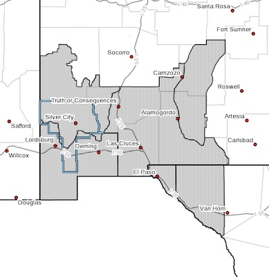
NEW MEXICO FIRE WEATHER ZONE 110
SOUTHWEST MOUNTAINS/GILA NF/APACHE NF/GLZ-
NEW MEXICO FIRE WEATHER ZONE 111
SOUTHWEST DESERTS AND LOWLANDS/LAS CRUCES BLM/GLZ-
NEW MEXICO FIRE WEATHER ZONE 112
SOUTH CENTRAL LOWLANDS AND SOUTHERN RIO GRANDE VALLEY/BLM/GLZ-
NEW MEXICO FIRE WEATHER ZONE 113
CAPITAN AND SACRAMENTO MOUNTAINS/LINCOLN NF/LNZ-
TEXAS FIRE WEATHER ZONE 055
EL PASO COUNTY-TEXAS FIRE WEATHER ZONE 056
HUDSPETH COUNTY-
516 AM MDT Sat May 1 2021
...RED FLAG WARNING IN EFFECT FROM 11 AM TO 9 PM MDT SUNDAY FOR
STRONG WINDS AND LOW RELATIVE HUMIDITY FOR FIRE WEATHER ZONES
055, 056, 110, 111, 112, AND 113...
The National Weather Service in El Paso Tx/Santa Teresa has
issued a Red Flag Warning, which is in effect from 11 AM to 9 PM
MDT Sunday. The Fire Weather Watch is no longer in effect.
* AFFECTED AREA...Southwest and South-Central New Mexico Fire
weather zones 110, 111, 112, and 113, and Far West Texas fire
weather zones 055 and 056.
* WIND...Southwest 20 to 25 with gusts up to 40 MPH.
* HUMIDITY...6 to 13 percent.
* IMPACTS...any fires that develop will likely spread rapidly.
Outdoor burning is not recommended.
PRECAUTIONARY/PREPAREDNESS ACTIONS...
A Red Flag Warning means that critical fire weather conditions
are either occurring now, or will shortly. A combination of
strong winds, low relative humidity, and warm temperatures can
contribute to extreme fire behavior.