 CRITICAL FIRE WEATHER TODAY AND AGAIN ON FRIDAY DUE TO EXTREMELY LOW HUMIDITY AND STRONG WINDS... .Extremely low humidity and above normal temperatures continue through Friday. Winds will be from the west between 20 to 30 mph through the evening and winds on Friday will be from the southwest between 35-45 mph. These winds combined with single digit relative humidity values will lead to high fire danger. Conditions on Friday could lead to a potentially active day for fire weather.
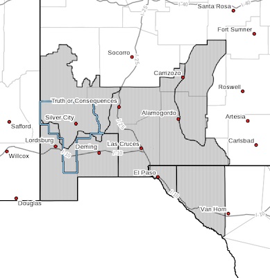
RED FLAG WARNING REMAINS IN EFFECT UNTIL 8 PM MDT THIS EVENING
FOR HIGH WINDS AND LOW HUMIDITY FOR FIRE WEATHER ZONES 055, 056,
110, 111, 112, AND 113...
...RED FLAG WARNING IN EFFECT FROM NOON TO 8 PM MDT FRIDAY FOR
STRONG WINDS AND LOW HUMIDITY FOR FIRE WEATHER ZONES 055, 056,
110, 111, 112, AND 113...
The National Weather Service in El Paso Tx/Santa Teresa has
issued a Red Flag Warning, which is in effect from noon to 8 PM
MDT Friday.
* AFFECTED AREA...Fire weather zones NM110, NM111, NM112, NM113,
TX055 and TX056.
* WIND...35 to 45 mph with gusts up to 55 mph.
* HUMIDITY...6 to 14 percent
* IMPACTS...any fires that develop will likely spread rapidly.
Outdoor burning is not recommended.
PRECAUTIONARY/PREPAREDNESS ACTIONS...
A Red Flag Warning means that critical fire weather conditions
are either occurring now, or will shortly. A combination of
strong winds, low relative humidity, and warm temperatures can
contribute to extreme fire behavior.