 CRITICAL TO EXTREME FIRE DANGER FRIDAY DUE TO LOW HUMIDITY AND STRONG WINDS... .A high-end fire weather event is setting up for tomorrow as winds increase from the southwest in response to a passing Pacific low over the Southern Rockies. Southwest winds will peak during the afternoon hours at 30 to 45 mph with gusts 50 to 70 mph. Very low humidity and above normal temperatures continue through Friday. Strong winds and critically dry fuels will increase the risk for rapid fire spread. 302 AM MDT Thu Apr 21 2022
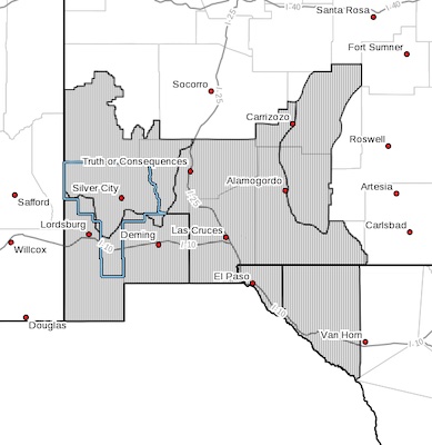
...RED FLAG WARNING NOW IN EFFECT FROM 10 AM TO 10 PM MDT FRIDAY FOR VERY STRONG WINDS AND VERY LOW HUMIDITY FOR FIRE WEATHER
ZONES 055, 056, 110, 111, 112, AND 113...
* AFFECTED AREA...Fire weather zones NM110, NM111, NM112, and
NM113 in southwest and south-central New Mexico, and TX055 and
TX056 in far west Texas.
* WIND...Southwest at 30 to 45 mph with gusts of 50 to 70 mph.
* HUMIDITY...6 to 14 percent
* IMPACTS...any fires that develop will likely spread rapidly.
Outdoor burning is not recommended.
PRECAUTIONARY/PREPAREDNESS ACTIONS...
A Red Flag Warning means that critical fire weather conditions
are either occurring now, or will shortly. A combination of
strong winds, low relative humidity, and warm temperatures can
contribute to extreme fire behavior.